Tuesday, June 30, 2015

Lines of storms moving through parts of Michigan

Some intensifying lines of thunderstorms are currently moving through areas of both northern and southern lower Michigan. None are severe warned, but they look as though they could cross that threshold. Stay safe out there.

Independence Day Outlook - *PERFECT* Weather


After some spotty rain this week, a fantastic high pressure ridge will be building into lower Michigan, pushing both the encumbering moisture and associated precipitation well to our south. The result? Pristine, sunny Michigan weather for the Fourth of July!  It will be warm enough for lakeshore activity but mild enough that standing by an outdoor grill will be enjoyable, too.

Daytime highs should approach 80 and might clear it in some areas of Michigan, specifically north/central lower and western upper Michigan.

For more details, I defer to Mr. Mark Torregrossa.  Get out and enjoy those barbecues, fireworks and underwater antics!

Sunday, June 28, 2015

A stable week ahead, followed by a slight chance of strong storms next Monday

Stability is going to be the word this week.  The jet stream is staying to our south almost in a late winter/early spring like pattern, which is going to keep temperatures mild and the atmosphere relatively quiet.  There will be a few chances for rain or even a thunderstorm over the next few days, but there's little to no chance for any nasty weather of note.

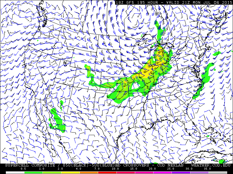
With that in mind, the GFS model is beginning to hint that Michigan could see some severe weather on Monday or Tuesday of next week.  It is forecasting that a reasonably strong low pressure system will move into eastern Alberta/western Ontario around that time, and that a moderate low level jet will bring up some very moist air from the Gulf of Mexico leading to some ridiculously high dew points to the tune of 70°+.


If this scenario does play out, it doesn't look like it would be very significant... not anywhere near the scale of last Monday's event.  Wind shear is predicted to be modest at best, and there's a question as to how much instability will be present, but for now there's enough ingredients to create some yellows on the SCP in a few different model runs.


If the forecast should verify, I wouldn't be surprised if a few strong to severe cells pop up somewhere in the state, though it's way too early to tell exactly what this system will do yet.

In unrelated-but-pretty-cool news, as I was driving down to Lapeer for work this evening, I managed to snap a couple pictures of what appeared to be a cumulus cloud with a somewhat lenticular base.


All the clouds seemed to show signs that there was some slightly strong wind shear over the region. As I was coming home, I even noticed a couple cold air funnel clouds, though unfortunately it was too dark to get good pictures of those.  These funnel clouds pose no danger, and usually form in the wake of a cold front where the mixed layer is just unstable enough to form decent clouds, and there's enough directional shear to make those clouds rotate.

Saturday, June 27, 2015

A potential washout of a weekend

Latest model guidance is suggesting that the jet stream is going to dive well to the south of Michigan over the next few days.  This should serve to keep temperatures much cooler than normal for the duration.  On top of this, a strong storm system looks as though it will form to our immediate south and east tonight, then roll northward over the weekend.  This will bring southeast Michigan a chance of some fairly heavy rainfall - up to 3 inches in some locations.


I'm a bit concerned about localized flooding on this one, particularly in the Detroit area and even up to some areas of the southern thumb. The NAM4KM is the most aggressive in terms of rainfall accumulation, especially in the last couple of runs...


...However, it's suggesting somewhat ridiculous amounts of rain in some locations (14.75 inches in one area of Indiana, and 8.38 inches in northeast Ohio), so I'm not sure how reliable its forecast is just yet. Either way, I'd not make too may outdoor plans for the weekend if you live in said regions. Conversely, western and northern lower Michigan will likely remain dry, if a little cloudy.

I finally did it...

So, after being told numerous times by my fianceĆ© and others I know that I should create a weather blog, I've finally gone and done it.  This blog will likely take the place of my long Facebook ramblings about the weather, though I still plan to make (shorter) posts there.

The way it will likely go is that if I have a lot of pictures or information to post, I'll make a post here, followed by a post on Facebook linking to here.  This way, people don't have to click through numerous images on Facebook to read descriptions, and I'm not always being condensed into "See More" brackets.  I hope that the aesthetics will also be a bit more pleasing.

I look forward to a fun future for this little project.