Thursday, July 7, 2016
Severe weather chances BACK ON for tomorrow afternoon, especially for northern lower MI and the Thumb
A severe thunderstorm warning is currently in effect for the Houghton Lake and St. Helen areas of Roscommon County as a powerful cluster of storms moves through the area. Some rather strong storms are also present north of Grand Rapids, in an east/west line between Shelby and Big Rapids. These storms will continue to propagate eastward, and a great deal of the lower peninsula could (finally) be wet by tomorrow morning.
...Which leads me to an important conclusion about tomorrow, and is also the reason that the SPC has a great swath of lower Michigan now under a slight risk for severe weather tomorrow as well. This system has picked up some steam.
By 9AM tomorrow morning, the rain should be off to the east and skies should be clear. This means that most of the full power of the day's sun should arrive to increase instability levels. Some models are showing very high instability levels, but NWS Detroit currently estimates things to top out at around 2000j/kg of SBCAPE by tomorrow afternoon. This is still more than enough instability to power thunderstorms, and with the system amping up in terms of power there are signs that the rockets could actually launch this time around.
The NAM4KM in particular is signalling some intense thunderstorm potential. It's forecasting supercells with some very powerful rotating updrafts, which could signal a tornado threat. These would then merge into a line and bow outward as they become more forward dominated, which would present a very strong damaging wind threat. The track of the storms being predicted is evident in the pictures above.
Two runs of this model have made this prediction, and the Rapid Refresh looks to be setting up a similar scenario.
40-50kts of bulk shear should provide more than enough horsepower to keep things running strong. Storms are forecast to ignite around 2-3PM across the area, which would mean they'd intensify as peak heating hours arrive. My hope is that this actually pans out this time, as a great deal of Mid Michigan is officially under a moderate drought (see image below). We absolutely positively need nt just rain, but thunderstorms that bring intense rainfall in order to turn things around.
Let's make this happen this time, Mother Nature! We need water!
Looking better for rain tomorrow, severe threat pretty much gone for eastern MI
It looks as though we won't have any severe weather to worry about on this side of the state today or tomorrow. The rain potential looks about on par with if not a little greater than last weeks. As these storms will come through in the morning, we shouldn't have to worry about things drying up before they pass through the area.
Most forecasts have pegged about a half inch of rainfall throughout the eastern areas, but some areas (like Flint) may get lucky and see up to an inch.
Wednesday, July 6, 2016
Chance of thunderstorms today looks better, potentially widespread rain tomorrow, Friday
Chances for precipitation in the lower peninsula look to be increasing as more models come out. The SPC continues its marginal risk for the northern half of the lower peninsula, and I'm now seeing more evidence in the models of potential thunderstorm development in the state than yesterday when the marginal risk covered the entire region. To that end I've actually included the Thumb area in a marginal risk in my outlook as a pop-up severe storm can't be ruled out during peak heating time, per model guidance.
Some models are suggesting that tomorrow afternoon may be quite active for the southernmost portion of the state, while others are downplaying the northward extent of the activity/potential. I currently don't think there's much of a threat for severe weather in Michigan tomorrow per se, so I'm matching the SPC's current outlook of slight risk for extreme southwest and marginal for most of the rest.
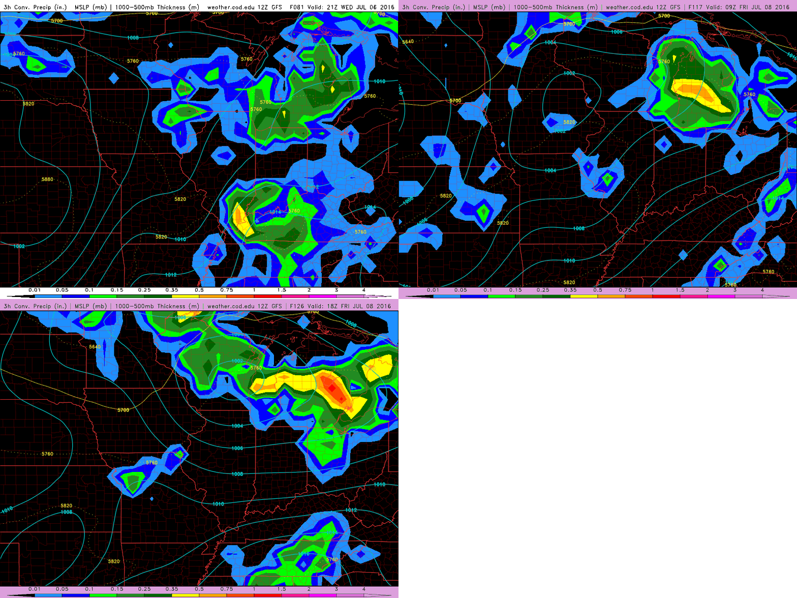
Friday is still a crapshoot depending on what happens today and tomorrow. I'm still thinking the eastern portion of the state could be looking at some severe weather based on the latest models, especially the high-res ones. I'm going to maintain my isolated/severe likely outlook for now pending the midday run. Right now the NAM4KM has thunderstorms popping up over western lower MI on Friday at around 2PM. These would likely gain strength as the front moved east in an increasingly unstable and sheared environment.
Tuesday, July 5, 2016
Friday looks like the best shot at storms
I'm going to start off by giving my opinion: I do not agree with the SPC's current marginal risk status assigned for Michigan tomorrow - I simply do not believe we're looking at any severe hazards, and that rain, let alone strong storms, will be hard pressed to survive the night into our area. It's much more likely that the storms out west will dip south through Illinois and skip Michigan completely, leaving only a few chance showers for our region until Thursday.
The jury is out on Thursday. The GFS and lower res NAM models indicate widespread rain present over the lower peninsula, though the higher res NAM4KM indicates nothing of the sort. It'll be interesting to see what the higher res models come in with over the next few hours. Keep in mind that the GFS continues to predict widespread rain for tomorrow, so I don't know if I trust its forecast much right now.
Friday, for now, definitely looks more interesting. The classic hallmarks of a severe thunderstorm-producing system are all present in the forecast. That said, this has happened before this year, and nothing has panned out, so this outlook is tentative at best. I think it's safe to assume a decent chance of strong to severe storms in at least the eastern part of the state on Friday afternoon.
Temperatures are definitely tempered back from what was earlier predicted, approaching if not quite making it to 90°. Dewpoints will likely be around 70°, making a for a very humid end of the week.
The jury is out on Thursday. The GFS and lower res NAM models indicate widespread rain present over the lower peninsula, though the higher res NAM4KM indicates nothing of the sort. It'll be interesting to see what the higher res models come in with over the next few hours. Keep in mind that the GFS continues to predict widespread rain for tomorrow, so I don't know if I trust its forecast much right now.
Friday, for now, definitely looks more interesting. The classic hallmarks of a severe thunderstorm-producing system are all present in the forecast. That said, this has happened before this year, and nothing has panned out, so this outlook is tentative at best. I think it's safe to assume a decent chance of strong to severe storms in at least the eastern part of the state on Friday afternoon.
Temperatures are definitely tempered back from what was earlier predicted, approaching if not quite making it to 90°. Dewpoints will likely be around 70°, making a for a very humid end of the week.
Sunday, July 3, 2016
Temperatures not as impressive, but still high - Chances for multiple rounds of rain/thunder look good
Big changes to the forecast from yesterday in terms of temperatures - I no longer think we're looking at record highs. In terms of precipitation, a very positive forecast is being put forth by the GFS which indicates multiple rounds of rain and/or thunder likely to affect Michigan toward the middle to end of next week. This looks more like a common late June/early July pattern than the absurdly dry one we've seen so far this summer.
The NAM is starting to get involved in the forecast, too, and hot temperatures look to be on the way even earlier than I first expected, but not to the same degree as what was put out yesterday. The model is forecasting temperatures in the upper 80s to low 90s by Tuesday, and potentially the low-to-mid-90s by Wednesday. This should be a very humid heat, too, with lots of moisture to make it feel even hotter. Dewpoints in the 60s and 70s will make things feel somewhat uncomfortable. The good news is that it definitely looks less oppressive by Friday, where as yesterday these conditions were looking as though they'd last beyond next week. The absurdly high 80° dewpoints appear to be gone from the forecast, too, though I never put too much stock in those. We do not currently look likely to hit 100°F anymore, either.
I'm still hoping that this week will mark the end of our abnormally dry conditions this summer. We have the opportunity for several rounds of rain and thunder in the Great Lakes region as several potent waves make their way toward Michigan beginning Wednesday. This potential should last until Friday and into the weekend. It's going to be all about track and timing. The odds are with us this time around that at least one of these waves will produce something. I'm hoping we'll bat 1000 this time around, and be well and mighty drenched by this time next week.
Saturday, July 2, 2016
Get ready for the heat - Multiple rounds/days of severe weather possible, too
Well, here we go again with another teaser. One of two things are going to happen within the next week: we're either going to sink into drought, or we're going to break our dry snap in an epic fashion.
The GFS in particular looks very promising, if not a little concerning. I'd be much more concerned if the patterns had favored us for storms as of late. This pattern is looking similar to what I was watching in the middle of June, when everything started looking like it was going to explode, but then decided to fizzle out and skip Michigan. It also shares some characteristics to what I was looking at toward the end of June in that, should it manifest, it could be a multi-day severe weather event. Keep in mind that multi-day doesn't necessarily mean multiple days in Michigan, or even one day in Michigan, but that potential is definitely there.
First up let's talktemperatures record highs. Fact: we're looking at multiple 90° days here. Even the usually temperature conservative ECMWF is throwing 90s around like they're nothing. And when I say multiple I mean a potential four-to-five day stretch. We have a very legitimate shot at 100°+ on one or two of those days. I see no relief on the horizon until the 13th or the 14th at the earliest. This has been predicted over several consecutive model runs and by different models, so it has a very good chance of happening. 2016 may go down as one of the hottest summers in Michigan on record.
Next, let's talk dewpoints. If you shudder at the thought of 100°F weather, you may want to pack your bags and head to Canada for the next week, because the dewpoints are going to make it feel like it's much hotter - 10 to 20 degrees hotter. Widespread 70° dewpoints are almost certain, with multiple days of 75° dewpoints possible. Think that's oppressive? There's even some hits in the models that dewpoints will make a run at 80°F. Consider what that means for a moment: imagine that it's 80° outside, and there's fog as thick as pea soup. That's the amount of moisture in the forecast. 70° dewpoints are considered tropical. When you start getting higher than that, we're talking equatorial rainforest here.
The GFS in particular looks very promising, if not a little concerning. I'd be much more concerned if the patterns had favored us for storms as of late. This pattern is looking similar to what I was watching in the middle of June, when everything started looking like it was going to explode, but then decided to fizzle out and skip Michigan. It also shares some characteristics to what I was looking at toward the end of June in that, should it manifest, it could be a multi-day severe weather event. Keep in mind that multi-day doesn't necessarily mean multiple days in Michigan, or even one day in Michigan, but that potential is definitely there.
First up let's talk
![]() |
| Yes, you're seeing that right. That's a hundred degree forecast for Monday July 11th. |
Friday, July 1, 2016
Widespread, if not particularly intense rain this morning - Turnaround on the way?
Some potential good news may be on the horizon for the abnormally dry, not-quite-drought-stricken lower peninsula. It starts with what occurred this morning - the MCS out of the northwest held together pretty good this time around, and just about the entire state saw some measurable, if not quite decent rainfall.
This rainfall is not nearly enough to offset the extended dry period we've been seeing over the last few weeks, but it hopefully will be enough to keep the dust down a bit better and reduce some of the fire weather conditions to the point where the Fourth of July will be a relatively safe holiday. No statewide fireworks bans are anticipated at this time. As always, check with your local county sheriff as to which days it is safe and lawful to set off fireworks.
The other part of the good news may be what's to come; our ridiculously dry June may give way to a more normal first few weeks of July. I warn you straight away - for this prediction, I'm turning to the models, and we know how those have been over the past month. However, I do believe that there's only so many times you can roll snake eyes before you HAVE to get something else, and more than a few model runs have been suggesting some decent thunderstorm potential over the coming week to two weeks.
There's a bit of back-and-forth regarding the mid-to-upper level winds and the east/west position of an upper-level trough in the last couple of GFS runs. This could have a big impact on where storms first fire up and what their upper level support will be, but it looks like low level and surface conditions will begin to become ripe for thunderstorm development in the Great Lakes region starting next Thursday. Temperatures should soar into the upper 80s and low 90s. Thursday has nothing on Friday, though; upper 90s to even 100°F are being forecast for Friday, July 8th. Dewpoints are forecast to be nothing short of oppressive to the tune of 75° - even if we come out on the low end of this forecast, we're going to have low-to-mid 90s with 70° dewpoints. This should send heat indexes into dangerous territories which we haven't seen in a few years. A real risk of heat-related injuries may be present throughout Michigan on Friday. To give you some idea of what we could be looking at, the calculated heat index of the worst case scenario being put forth by this model (temperature of 100°, dewpoint of 76°) equates to 115°. Stay close to areas with air conditioning next week.
All of this heat should produce a ridiculous amount of instability in the atmosphere. The question now is going to be what kind of capping and forcing for ascent will come along with it. The latest GFS has the cap eroding by Friday over Wisconsin. This could lead to widespread thunderstorm development and a potential MCS (widespread linear/semi-linear storm system) moving into Michigan overnight Friday into Saturday, if the position of a cold front cooperates. The GFS has a warm front moving into the area Friday and a cold front not far behind it, so this could easily happen. Storms could also develop along the warm front, though again, this is going to depend heavily on how much capping is in place at the low levels of the atmosphere. This model is also hinting that low level wind speed should be quite strong - 40-50kts. Mid level winds are a bit more tame, so bulk shear values are coming in around the same, but with mid-level winds that strong any storms should have a chance to be more organized.
From what I can see, the latest ECMWF is mostly in agreement with the GFS, although its range is somewhat limited at this point. More will be shown in subsequent runs. Rumblings from NWS Detroit seem to also indicate better chances for thunderstorms in the coming week. The latest forecast discussion expressly mentions a better chance for scattered convection. The SPC also specifically mentions a severe risk in the upper Great Lakes during the day 5-7 period, though predictability concerns preclude any highlighted areas.
The forecast definitely looks better than it did a week ago, and hopefully this morning's rain will reduce some of the allergy misery. THAT, at least, can't get any worse!
This rainfall is not nearly enough to offset the extended dry period we've been seeing over the last few weeks, but it hopefully will be enough to keep the dust down a bit better and reduce some of the fire weather conditions to the point where the Fourth of July will be a relatively safe holiday. No statewide fireworks bans are anticipated at this time. As always, check with your local county sheriff as to which days it is safe and lawful to set off fireworks.
The other part of the good news may be what's to come; our ridiculously dry June may give way to a more normal first few weeks of July. I warn you straight away - for this prediction, I'm turning to the models, and we know how those have been over the past month. However, I do believe that there's only so many times you can roll snake eyes before you HAVE to get something else, and more than a few model runs have been suggesting some decent thunderstorm potential over the coming week to two weeks.
There's a bit of back-and-forth regarding the mid-to-upper level winds and the east/west position of an upper-level trough in the last couple of GFS runs. This could have a big impact on where storms first fire up and what their upper level support will be, but it looks like low level and surface conditions will begin to become ripe for thunderstorm development in the Great Lakes region starting next Thursday. Temperatures should soar into the upper 80s and low 90s. Thursday has nothing on Friday, though; upper 90s to even 100°F are being forecast for Friday, July 8th. Dewpoints are forecast to be nothing short of oppressive to the tune of 75° - even if we come out on the low end of this forecast, we're going to have low-to-mid 90s with 70° dewpoints. This should send heat indexes into dangerous territories which we haven't seen in a few years. A real risk of heat-related injuries may be present throughout Michigan on Friday. To give you some idea of what we could be looking at, the calculated heat index of the worst case scenario being put forth by this model (temperature of 100°, dewpoint of 76°) equates to 115°. Stay close to areas with air conditioning next week.
All of this heat should produce a ridiculous amount of instability in the atmosphere. The question now is going to be what kind of capping and forcing for ascent will come along with it. The latest GFS has the cap eroding by Friday over Wisconsin. This could lead to widespread thunderstorm development and a potential MCS (widespread linear/semi-linear storm system) moving into Michigan overnight Friday into Saturday, if the position of a cold front cooperates. The GFS has a warm front moving into the area Friday and a cold front not far behind it, so this could easily happen. Storms could also develop along the warm front, though again, this is going to depend heavily on how much capping is in place at the low levels of the atmosphere. This model is also hinting that low level wind speed should be quite strong - 40-50kts. Mid level winds are a bit more tame, so bulk shear values are coming in around the same, but with mid-level winds that strong any storms should have a chance to be more organized.
From what I can see, the latest ECMWF is mostly in agreement with the GFS, although its range is somewhat limited at this point. More will be shown in subsequent runs. Rumblings from NWS Detroit seem to also indicate better chances for thunderstorms in the coming week. The latest forecast discussion expressly mentions a better chance for scattered convection. The SPC also specifically mentions a severe risk in the upper Great Lakes during the day 5-7 period, though predictability concerns preclude any highlighted areas.
The forecast definitely looks better than it did a week ago, and hopefully this morning's rain will reduce some of the allergy misery. THAT, at least, can't get any worse!