Thursday, June 2, 2016

June 9th-10th upcoming severe weather potential

As expected, the SPC has cancelled the Saturday severe risk for Michigan. Only a general thunderstorm risk remains, with a very small section of the U.P. under a marginal severe risk.

The coming weeks should be much more active.

Several runs of the GFS are predicting elevated severe weather potential in the state on Thursday, June 9th and Friday June 10th. The latest run of the ECMWF is beginning to hint at it, too.
Thursday June 9th
Friday June 10th

On both days, conditions are forecast to be moderate to strongly unstable (1500-2500j/kg SBCAPE) as a warm front moves into the area, bringing dewpoints in the upper 60s. Surface winds may be a bit stronger this time around, especially on Friday - between 15-25kts. Low-level winds could reach 50kts, and mid-level winds could be around 60-70kts. Storms would be coming from the north on this one, which would be similar to the August 2nd setup last year. It's not looking quite as intense as that scenario just yet, though. In terms of intensity, as of now this is looking like it could be about a 4 out of 10. August 2nd was more like a 7 out of 10.

On Thursday, for now, I'm predicting that severe thunderstorms will be likely along and north of the US-10 corridor where it appears storms are most likely to occur. This is where the most frontal interaction should take place, at least according to this forecast. To the south, there will be less of a risk, despite just as much if not more instability, as there'll be less forcing for ascent to start the engines. For Friday, I'm only predicting isolated severe storms for now, as the GFS is not suggesting that many storms will form on Friday due to lack of forcing despite a strong conditional threat.

Wednesday, June 1, 2016

Severe potential today, Saturday appears low to me

The marginal risk that the SPC has put out for today has shrank even further to the west. I honestly doubt we're going to see any storms of note this afternoon - just general rain and thunder. The U.P. has a slightly better chance of seeing bigger storms, but that chance is still fairly low.


Curiously, the SPC has introduced a 15% risk area for severe weather in Michigan this Saturday. I'm not sure if I'm feeling it on this one either. They flat out mention that the only reason they're doing this is due to a mid-level jet of 40-50kts expected, however this has gone down in the latest model run and so I foresee this outlook being adjusted downward tomorrow unless something major changes in the forecast. Instability is predicted to be very low on Saturday and dewpoints are looking to struggle to reach even 60. We'd have to have a whopper of a wind storm to power severe weather at those levels, and what I'm seeing in the models just isn't up to snuff.

Tuesday, May 31, 2016

Upcoming severe weather potential - Week of June 12th

Not much of an update on tomorrow's severe storm outlook; the SPC has maintained the marginal risk in just about the same area as it is. I'm feeling a little more potential than I was, as the NAM is suggesting stronger SBCAPE values than before, however the NAM has had a tendency to exaggerate instability lately, so it could easily be doing so again. Regardless, wind speeds aloft aren't going to be anything to ring bells about. One or two storms might just barely get above severe limits, but it's likely to be a similar set up to Sunday afternoon at best, with only a few warnings going out.

On the distant horizon, however, things are starting to look like they could be a different story.


I mentioned the other day that the long-range climate models were predicting some nastiness toward the end of June. Some of the runs were predicting some ugliness for the middle of June, too. Now that the GFS is just barely able to see that far, it's starting to show signs of trouble, too. This is, of course, very early, but these type of trouble indicators can foreshadow severe weather events like they did last year. The June 22nd event began to show up several weeks out, and was placed initially as far west as Minnesota. This is placing the nastier conditions in the Wisconsin/Illinois area for now, but that can easily change.

To give you a good idea of what kinds of problems could be associated with conditions like this, here's the forecast sounding for the dead center of that red bullseye:


Associated with similarly observed soundings were four storms which produced significant tornadoes. Significant tornado potential is rated at a whopping 7.5 out of 11. The only reason I'm imagining this sounding isn't generating the "potential hazard type" as "PDS TORNADO" rather than just plain "TORNADO" is that the critical angle is a bit tight at 73°. Still, if the winds get anywhere near as strong as what's being predicted there, you wouldn't need much instability to drive a major event. Based on wind direction and speed, this proposed scenario is reminding me a bit of what occurred on August 2nd of last year.

Again, we're way early here. This could manifest to our west and dive south, leaving us in the cold sector of a storm system rather than the warm, violent sector. Even if the system stayed on course, we could wind up with convective overturn as we have the past few times should it spawn storms to the west. Or, the system may not even manifest at all. I definitely believe it's worth talking about and keeping an eye on, though.

Monday, May 30, 2016

Wednesday June 1st likelihood of strong thunderstorms

The SPC has introduced a marginal risk to the day 3 categorical outlook over the western ¾ of lower Michigan regarding a slightly stronger frontal system that should be passing through on Wednesday.


This is powered by a stronger upper level disturbance and slightly more powerful surface low than we've seen thus far. Nonetheless, I'm not quite sure if I'm feeling this one yet. Instability looks like it's going to be very weak - on the order of 500 to 1000j/kg of MUCAPE. While the mid-range models are definitely hinting at a widespread area of thunderstorms developing, I'm not sure wind speeds are going to be up to snuff, either. Early projections are putting surface winds at only 10-15mph over the area. The winds could be strong enough to drive severe weather if there's a bit more instability to work with, so as always, it's going to be all about timing. If the system comes through a little earlier and can work with the day's peak heating, the storms might be a bit stronger. While winds are forecast to be forward veering, I doubt they're going to be strong enough to provide for even a weak tornado risk. For now the forecast is that the storms will come through at the end of the day, and that brief period where they could tap into the better levels of instability supports a very marginal damaging wind risk.

Sunday, May 29, 2016

Eastern MI - Thunderstorms incoming in the next hour

A marginal risk for severe weather remains this afternoon for the eastern portion of the lower peninsula. The high-res short term models show storms developing within the next 4 hours across the region as the cold front begins its journey through the state.


Most of these storms should stay below severe limits, but there remains a chance that one or two could cause some damaging winds or large hail before all is said and done.

I'm keeping an eye on this Wednesday/Thursday afternoon as well regarding severe potential in Michigan, however as of right now the risk again looks marginal at best.

Friday, May 27, 2016

It could be one of those Junes - Late month likely to be VERY active

I'm going to wait to talk about Sunday's severe potential until a few more runs come in, as the mid-range models have been kinda flaky lately and have over-embellished a bit. As of now the SPC has outlined a marginal risk for severe weather throughout lower Michigan. Sunday should be the curtain call to this very slow-moving system, as the cold front is finally on track to move through our state then. The most widespread forcing yet will be present as this boundary finally moves through, so the most widespread storms should take place Sunday, regardless of mode or severity. Now, onto the topic at hand.

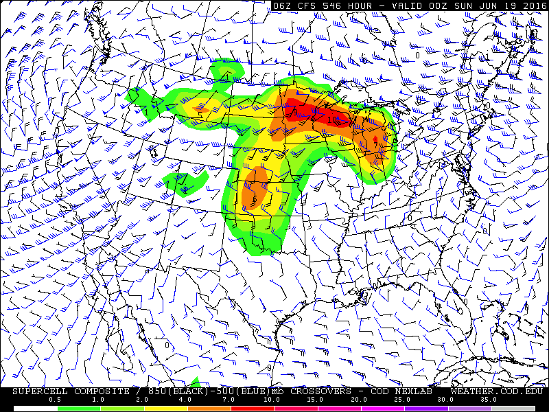
The long range climate forecast models made the proverbial exclamation point appear above my head this afternoon. I'm actually quite a bit more concerned about this than I would otherwise be this far out for a couple of reasons which I'll touch on below, but there's some strong indications that the plains' severe weather season may draw to a close before really taking off and ours will inherit the difference. Most of you who are reading from the Tri Cities and Thumb probably remember last June 22nd well. You may recall in the lead up to that day that the models were hinting at something nasty several weeks out. You may also recall me mentioning that the event could've been a lot worse had we experienced one round of storms rather than two - some of the energy of the day was sapped by early morning thunderstorms. I don't want to alarm anyone, but what's showing up in the long range models are indicating an event similar to the original scope of last June's, only this time it's indicating several days of potential rather than just one or two. This means a couple of things. The first is that the event, should it take place, could come in higher on the scale than last year's. This could be a true multi-day severe weather outbreak, or even a derecho.

You may remember that at the beginning of the month I mentioned that a multi-day severe weather event was possible. This manifested for the Great Plains and could've manifested here had there been a little more wind to drive thunderstorms. I'm actually quite impressed with the accuracy of the long-range model in predicting the bullseye (Kansas). The event culminated into a moderate risk day there two days ago. May is prime-time severe weather season for Tornado Ally. This is one of the reasons I'm concerned about the June forecast: late May isn't truly part of our severe weather season - most of our bigger storms come in June and July, when the jet stream still tends to be overhead as the much hotter air from the tropics billows up from the Gulf. This is even more true in the warmer summers, like the one we're looking to have this year. We're much more likely to have severe weather in late June than in late May, and the CFSv2 model is painting the bullseye squarely on us this time around.


This would be something to look at even on its own, but it's coupled with the fact that it's showing up in multiple model runs:


...And there's an indication that this could be part of something much, much bigger than the average "one-and-done" Michigan severe weather day. This is the collection of images that has me most concerned.


Basically, conditions are predicted to be ripe for severe weather over the course of several days, and there's even some indication that this trend would continue past the point that the model can see (the final image shows quite a spike in Montana). When patterns like this show up in June, they need to be taken very seriously. Notice the flow from northwest to southeast across the Great Lakes. This tends to be the path that our derechos take. Supercells initially explode over North Dakota or Minnesota coalesce into a self-sustaining chain reaction of thunderstorms which then plow across hundreds of miles. When they take a right turn, they intensify even more. The storms we had on August 2nd of last year were a miniature version of something like this. They can bring hurricane force winds and tornadoes. The more extreme versions can bring winds up to category 4 hurricane strength and the phenomena that come with such intense events, such as storm surges ...on the Great Lakes. If the storms don't survive long enough to become a true derecho, depending on the intensity of the low-level jet, upper level winds, capping and level of instability, you can instead get discrete supercells off the outflow boundaries, and potentially strong, long track tornadoes as a consolation prize.

Again, I'm much more concerned when a pattern like this shows up in June than I am in May, when the Plains tend to be the most active. As stated, this model was very good at plotting out this week's events very early. This is one of the years where I think our severe weather will be a cut above average, and this early forecast is the first real indication of that being the case.

Thursday, May 26, 2016

SPC adjusts convective outlook, as do I

With little to no morning convection holding over to dampen the environment and a bright sunny day allowing temperatures to overachieve, I'm of the opinion that we're looking at the potential for stronger thunderstorms in the regions where forcing for ascent is going to be present - mainly the entire U.P. and the northern half of lower Michigan.


The SPC has their marginal risk encompassing these areas, however I believe the potential for significant storms also exists to the south, to around the U.S. 10 corridor. The environment around those areas should also be more conducive to stronger storms, as we'll be dealing with higher temperatures and more instability. The HRRR paints a picture of thunderstorm potential along those areas, as well as the NAM4KM (to a much greater degree). Dewpoints forecast by the HRRR aren't quite as high as what the NAM is predicting, so instability levels should be significantly less than what was originally forecast a few days ago.


With that in mind, this has been the little wave that could in terms of what it's doing in the plains states. A MODERATE risk for severe weather (including a 15% tornado risk with 10% significant tornado hatching) is now present in Kansas. This feeds the notion that is a bit more intense than what forecasters or even some of the models originally outlined, which leads me to believe the storms that do pop up could be a bit more intense here. Right now I'm thinking hail will be the primary threat.