
The long range climate forecast models made the proverbial exclamation point appear above my head this afternoon. I'm actually quite a bit more concerned about this than I would otherwise be this far out for a couple of reasons which I'll touch on below, but there's some strong indications that the plains' severe weather season may draw to a close before really taking off and ours will inherit the difference. Most of you who are reading from the Tri Cities and Thumb probably remember last June 22nd well. You may recall in the lead up to that day that the models were hinting at something nasty several weeks out. You may also recall me mentioning that the event could've been a lot worse had we experienced one round of storms rather than two - some of the energy of the day was sapped by early morning thunderstorms. I don't want to alarm anyone, but what's showing up in the long range models are indicating an event similar to the original scope of last June's, only this time it's indicating several days of potential rather than just one or two. This means a couple of things. The first is that the event, should it take place, could come in higher on the scale than last year's. This could be a true multi-day severe weather outbreak, or even a derecho.
You may remember that at the beginning of the month I mentioned that a multi-day severe weather event was possible. This manifested for the Great Plains and could've manifested here had there been a little more wind to drive thunderstorms. I'm actually quite impressed with the accuracy of the long-range model in predicting the bullseye (Kansas). The event culminated into a moderate risk day there two days ago. May is prime-time severe weather season for Tornado Ally. This is one of the reasons I'm concerned about the June forecast: late May isn't truly part of our severe weather season - most of our bigger storms come in June and July, when the jet stream still tends to be overhead as the much hotter air from the tropics billows up from the Gulf. This is even more true in the warmer summers, like the one we're looking to have this year. We're much more likely to have severe weather in late June than in late May, and the CFSv2 model is painting the bullseye squarely on us this time around.
This would be something to look at even on its own, but it's coupled with the fact that it's showing up in multiple model runs:

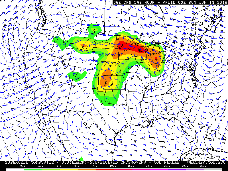
...And there's an indication that this could be part of something much, much bigger than the average "one-and-done" Michigan severe weather day. This is the collection of images that has me most concerned.

Basically, conditions are predicted to be ripe for severe weather over the course of several days, and there's even some indication that this trend would continue past the point that the model can see (the final image shows quite a spike in Montana). When patterns like this show up in June, they need to be taken very seriously. Notice the flow from northwest to southeast across the Great Lakes. This tends to be the path that our derechos take. Supercells initially explode over North Dakota or Minnesota coalesce into a self-sustaining chain reaction of thunderstorms which then plow across hundreds of miles. When they take a right turn, they intensify even more. The storms we had on August 2nd of last year were a miniature version of something like this. They can bring hurricane force winds and tornadoes. The more extreme versions can bring winds up to category 4 hurricane strength and the phenomena that come with such intense events, such as storm surges ...on the Great Lakes. If the storms don't survive long enough to become a true derecho, depending on the intensity of the low-level jet, upper level winds, capping and level of instability, you can instead get discrete supercells off the outflow boundaries, and potentially strong, long track tornadoes as a consolation prize.
Again, I'm much more concerned when a pattern like this shows up in June than I am in May, when the Plains tend to be the most active. As stated, this model was very good at plotting out this week's events very early. This is one of the years where I think our severe weather will be a cut above average, and this early forecast is the first real indication of that being the case.
No comments:
Post a Comment