Wednesday, September 30, 2015

Wintery temperatures arriving in northern MS Valley, creeping into our neighborhood

Here's an unfortunate prelude of things to come and a wake-up call to Michiganders who've yet to realize that we're only three full calendar months away from January 1st:

Among Winter Storm Warnings in Alaska and Hurricane Warnings in the Bahamas is a Hard Freeze Warning and Frost Advisory for very close to our area of the country.
A hard freeze warning and frost advisory are in effect for most of the northern Mississippi Valley and upper peninsula of Michigan. Most gardens are harvested by now, but if you have any plants you've left outside it's going to be time to wrap them up or take them indoors soon.  Grilling weather is officially on its way out.

The NAM's latest run predicts some chilly weather in our neighborhood by early morning Friday.  Lows in the 30s aren't out of the question, and I wouldn't be surprised if a few frost advisories are issued for central lower Michigan - particularly away from the lakeshore areas.
The nice thing about fall in Michigan is that the warm lakes actually help to insulate us against the oncoming cold blasts. This of course leads to heavy lake affect snow for the snowbelts during the early winter months, or even further into the winter depending on how warm the lakes are or how long they take to freeze.

I still wouldn't rule out one more chance of thunderstorms as 70° weather and that storm system still looks probable for the second week of October, though the jury is out on that one, and the setup isn't looking as strong as it was before. Our fall pattern does tend to resemble our summer one quite a bit, though, with gradual warming trends followed by cold air plunges. It's just that the temperatures will now reflect fall, where the warm air will be in the 70s rather than the 90s and the cold air will be closer to 30-40°.

Wednesday, September 23, 2015

Early October monstrosity? GFS predicts a dragon

Retiring the thunderstorm outlook for the fall may have jinxed us.

Something wicked has appeared in the later hours of the last couple of GFS runs. And I do mean wicked. Allow me to tell the tale of the picture that the GFS is painting.

A wintery blast of some of the first truly cold air of the year (30s, potentially even sub-30s) looks to descend into the central plains and upper Mississippi Valley.  A truly frightening 120kt+ negatively tilted upper level disturbance would be the driving force behind this cold blast.

Upper level winds associated with this trough are forecast to reach 120kts as of this latest run. 
At 18,000ft near the tops of the storms, winds would also be very strong.
North of this, a monstrous upper level surface low would develop with a central pressure to the tune of 980-990 hPa/millibars would develop.  To the southwest, a heat dome of 85° temperatures and 65° dewpoints...
85° on one side and 35° on the other makes for a potentially ugly situation.
Peak intensity as predicted by the latest GFS shows a negatively tilted behemoth at 990 hPa in the ideal position to wreak havoc on Michigan.  Timing of the day would not be the best for big storms according to this forecast, though.  
This is a witches brew for a very strong late season tornado outbreak, which at this point looks as though it may target the Great Lakes region. The biggest reasoning for my concern at this point is the sheer numbers in terms of temperature differential. If you have 80-85° temperatures with 60-65° dewpoints in place, and you blast 30° dry air into the region, you might as well be setting off a bomb in the atmosphere.

A lot of factors would have to come into alignment in order for this to produce severe weather, not the least of which is timing.  If the timing of the day is off on this one, we may wind up with nothing more than a few storms and a cold windy rainy mess. Position is also a big factor. This forecast may also shift significantly eastward as has happened previously with long-range GFS-predicted storms. Even if shows up where it is, there's no telling yet if Michigan would be the state to bear the full force, or if it would instead target Chicago/Indiana like in November of 2013. Just looking at this, though, I would not be surprised if I wind up pulling the outlook widget back out for one last event yet this year.

Tuesday, September 22, 2015

Summer 2015 in retrospect

A very active, stormy summer has officially drawn to a close. With little to no thunderstorm potential for Michigan on the long range model horizon, it's safe to say that our fall weather patterns are now in place, and the dreaded S-word will become the primary focus of this blog for the next few months. To that end, I'm retiring the thunderstorm outlook for the season; it will be restored in the event of a rare fall severe weather outbreak.

I'd like to briefly recap what the state saw this year in terms of weather for archive purposes.

The summer of 2015 was quite the wet one here Michigan.  The thumb area, in particular, has been saturated for several months, and is only now beginning to dry out.  We had a somewhat dry early spring, punctuated by little snowmelt and very few episodes of stratiform precipitation, however, once thunderstorm season kicked off, the tables turned significantly.  The state's capital wound up seeing it's third wettest June and third wettest month since records began being recorded in 1863. Just about every place records were taken in the state had above normal June precipitation totals, with most significantly above normal. July was also wet, though to a lesser degree, though August revved back up quite a bit as well. With that in mind, you might be surprised to find out that Michigan was actually on the moderate end of what it received for rainfall this year so far in comparison to other areas of the country. Pretty much the entire eastern two thirds of the country saw above-normal precipitation, with other areas of the Midwest receiving the most.

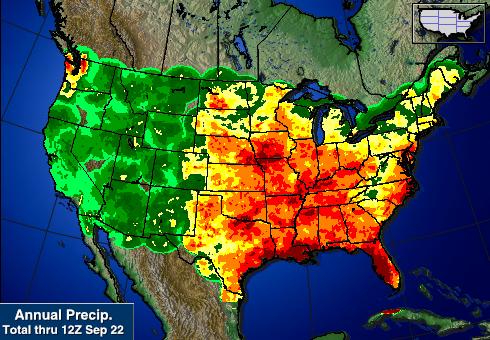
Michigan was actually spared the worst of the rain this summer when compared to other states.
Regarding severe weather, there were five major events that affected southeast Michigan this year. The first two events were on May 26th and May 27th, affecting mostly central lower MI on the first day and then extreme SE Michigan on the second day.  Neither were particularly widespread.  June 14th saw very heavy rain which caused flood damage, but little in the way of wind or storm damage.

A widespread severe weather event occurred in the afternoon and evening hours of June 22nd, 2015. For several days prior to this event, model data was indicative of a potentially major severe weather outbreak throughout the portions of central and southeast lower Michigan. The outbreak manifested itself in the form of a damaging MCS which moved through during the mid to late afternoon hours, and a series of tornadic supercells which formed during the early evening hours. One of these storms spawned an EF-2 tornado in the southeastern portion of Saginaw county, where it did considerable damage to a camp site and injured 2. It then moved into the Millington area of Tuscola county where it did considerable property damage. Estimated winds of this tornado were 115mph. Three other tornadoes touched down during this event, two of which were rated EF-1 and the third EF-0.

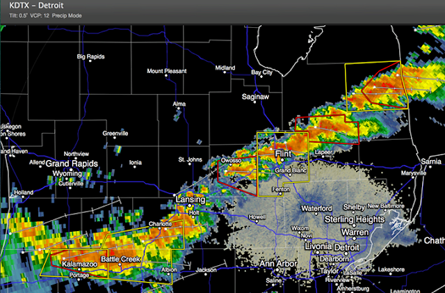
Line of storms (with warnings) from around 11:30PM EDT June 22nd 2015.
An even more widespread and intense event occurred throughout the day on Sunday, August 2nd. Four lines of very intense severe thunderstorms plowed across the state in a northwest-to-southeast movement, with just about every area of the lower peninsula affected, and a section extending from the Traverse City area into the Thumb particularly so.

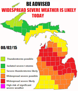
Counties highlighted in red were most affected by the August 2nd 2015 severe weather outbreak. 
A very strong cold front plowing into 90° temperatures with dewpoints in the 70s triggered this event, which produced storms with wind gusts to 80mph and up to softball sized hail.  One tornado was confirmed in Owendale, which is a small town in Huron County. This tornado was rated EF-1 and did significant damage to the local school, and completely destroyed one business.

Photos of clouds, hail and damage photos/reports from the August 2nd 2015 event.

A total of four tornado watches and eight severe thunderstorm watches were issued for areas of the state.

All in all, I'd say this is one of the more active summers in recent memory, at least for my neck of the woods. The thumb got drenched. Since no records are kept, it's tough to say just how much rain we got in comparison to other areas of the state. With that in mind, there were enough flooded fields and higher than usual streams to say we got just as much if not more than everywhere else. The August 2nd storms hit us especially hard, with essentially the entire lakeshore area of Huron County losing power, and major wind damage throughout.

Now that our severe weather season has wound to a close, I will probably be making fewer posts. In the event of a major winter storm that looks to affect the region, I will begin making more posts, but I'd fully expect not more than one or two posts a week during this duration, mostly covering historical events, climate data, temperature trends and updates from Andrew. I'll make a post sometime within the next few days about what my expectations are for this winter based on previous year analogues as well as rumblings from the scientific community.

Friday, September 18, 2015

Strong to severe storms possible *overnight* tonight

No thunder should arrive in the state prior to 11PM tonight, however the latest NAM4KM is predicting bigger storms showing up at around 3-4AM across the lower peninsula.


The National Weather Service Detroit/Pontiac office has highlighted specific concerns of damaging winds in the southeast Michigan area through the overnight, although there's some indication that a cap could prevent robust thunderstorm growth: 

...there will be very good warm advection/isentropic ascent farther north, leading to the
higher confidence/near 100 percent pops toward Saginaw Bay. With such dynamic system and potential
organized complex/mcs developing, damaging winds can not be totally ruled out as low level jet ramps
up to 50+ knots ( 60+ plus knots per regional GEM ) around 9z Saturday right near the surface cold
front, but that is partially an artifact of the surface inversion/stable layer developing, and thus
helping to mitigate the severe threat. 

So far, I'd say the chance of severe weather remains about 50/50, though I'd lean more toward bigger storms based on what I'm seeing from the model, particularly in the western portion of the state. With a cap present, storm modes should wind up being discrete, which is what the model suggests for the Saginaw Valley into the Thumb, which could even lead to rotation in some storms, especially should they interact with a lake breeze. Also based on what I'm seeing from the models, I have a sneaking suspicion tomorrows SPC highlighted marginal risk area for the Thumb southward will be cancelled by tomorrow morning, as thunderstorms should be out of our area by noon.

Thursday, September 17, 2015

Latest runs significantly downgrade Saturday's sever weather chances

Other than a slice of central/SE lower Michigan, it doesn't appear like we'll be seeing favorable conditions for severe weather on Saturday. Even for the areas in the SPC's marginal risk zone, the NAM is nowhere near as aggressive as it was in last night's model runs.

The latest NAM run is predicting conditions nowhere near as robust as what last night's runs were.
With that in mind, our day for big thunder looks like it may be tomorrow after all.  The SPC specifically mentions that an MCS might move through our area, bringing severe wind.  A marginal risk has been assigned for pretty much the entire lower peninsula for this time frame.

Wednesday, September 16, 2015

NAM getting aggressive on severe weather conditions over lower MI on Saturday

Each subsequent run of the NAM has increased the conditional parameters for severe weather on Saturday over lower Michigan. The latest run is depicting quite a boost from the last in terms of potentially unstable air.

The NAM is now predicting level of surface-based instability at or above 2000 j/kg.
Combine that with the wind profiles expected and you have surging severe weather parameters, with the supercell composite reaching 9 over central lower Michigan.
Significant tornado potential is also predicted to go up.
Of particular concern is the significant tornado potential rising to mid levels on the scale. This could make for a few good touchdowns should this forecast verify and should storms form/reintensify in such an environment. That's going to be the biggest factor, as this is awful close to the center of the low and I'm still hesitant to believe that leftover convection and/or stratiform precipitation that forms in this area won't negatively impact severe weather conditions.

I'm going to wait one more day to let the models chew on this one before updating the outlook for Saturday. By tomorrow, the SPC will also have something to say about Saturday. For now, there is at least a conditional marginal risk, which I will likely assign in the morning in the outlook barring significant changes in the forecast.

Warm front to pass through Friday - bigger storm potential Saturday?

Lower Michigan doesn't look to be under the gun at all for severe weather according to both the SPC and several different forecast models, however the NAM in particular is suggesting pockets of very unstable air present over the state Friday afternoon, and relatively unstable air again on Saturday. Both of the last two NAM runs have been fairly consistent in this feature.


We're definitely going to get wet on Friday, though I'm not sure to what degree we'll see new thunderstorm development, as forcing for ascent won't be particularly strong over the state.  The cold front is scheduled to come through on Saturday, which is when I'd expect the bigger storms save for one complicating factor - previous day convection; both whether or not it'll warm the mixed layer and whether or not it will cloud up the surface and prevent daytime highs from getting to the point where they'd cause trouble.

Instability isn't expected to be as high over the state on Saturday, however...
...the upper level disturbance...
...and associated surface low will be in an ideal position to cause strong thunderstorms in lower Michigan, provided that prior day convection or any stratiform precipitation that forms doesn't get in the way.
The NAM is forecasting the surface low associated with this relatively strong upper level disturbance to reach peak intensity on Saturday, though, which should definitely provide enough horsepower for any storms that do form to go severe.

I'll continue to watch the situation and make updates as new information comes along. For now, count on rain and thunderstorms both Friday and Saturday, with questionable intensity.