I'd like to briefly recap what the state saw this year in terms of weather for archive purposes.
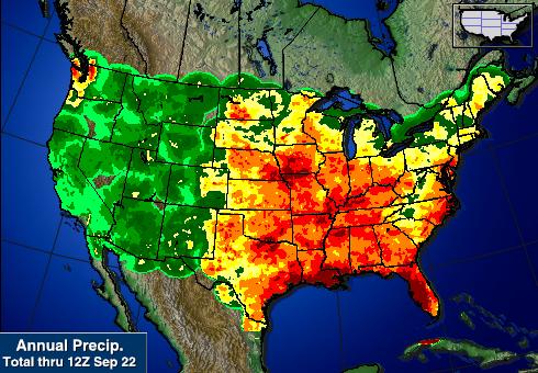
The summer of 2015 was quite the wet one here Michigan. The thumb area, in particular, has been saturated for several months, and is only now beginning to dry out. We had a somewhat dry early spring, punctuated by little snowmelt and very few episodes of stratiform precipitation, however, once thunderstorm season kicked off, the tables turned significantly. The state's capital wound up seeing it's third wettest June and third wettest month since records began being recorded in 1863. Just about every place records were taken in the state had above normal June precipitation totals, with most significantly above normal. July was also wet, though to a lesser degree, though August revved back up quite a bit as well. With that in mind, you might be surprised to find out that Michigan was actually on the moderate end of what it received for rainfall this year so far in comparison to other areas of the country. Pretty much the entire eastern two thirds of the country saw above-normal precipitation, with other areas of the Midwest receiving the most.
 |
| Michigan was actually spared the worst of the rain this summer when compared to other states. |
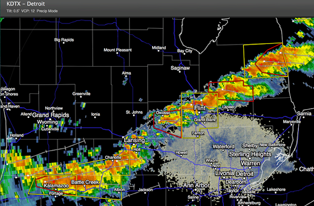
A widespread severe weather event occurred in the afternoon and evening hours of June 22nd, 2015. For several days prior to this event, model data was indicative of a potentially major severe weather outbreak throughout the portions of central and southeast lower Michigan. The outbreak manifested itself in the form of a damaging MCS which moved through during the mid to late afternoon hours, and a series of tornadic supercells which formed during the early evening hours. One of these storms spawned an EF-2 tornado in the southeastern portion of Saginaw county, where it did considerable damage to a camp site and injured 2. It then moved into the Millington area of Tuscola county where it did considerable property damage. Estimated winds of this tornado were 115mph. Three other tornadoes touched down during this event, two of which were rated EF-1 and the third EF-0.
 |
| Line of storms (with warnings) from around 11:30PM EDT June 22nd 2015. |
 |
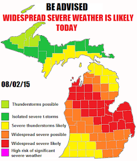
| Counties highlighted in red were most affected by the August 2nd 2015 severe weather outbreak. |
Photos of clouds, hail and damage photos/reports from the August 2nd 2015 event.
A total of four tornado watches and eight severe thunderstorm watches were issued for areas of the state.
Now that our severe weather season has wound to a close, I will probably be making fewer posts. In the event of a major winter storm that looks to affect the region, I will begin making more posts, but I'd fully expect not more than one or two posts a week during this duration, mostly covering historical events, climate data, temperature trends and updates from Andrew. I'll make a post sometime within the next few days about what my expectations are for this winter based on previous year analogues as well as rumblings from the scientific community.


No comments:
Post a Comment