Tuesday, May 31, 2016

Upcoming severe weather potential - Week of June 12th

Not much of an update on tomorrow's severe storm outlook; the SPC has maintained the marginal risk in just about the same area as it is. I'm feeling a little more potential than I was, as the NAM is suggesting stronger SBCAPE values than before, however the NAM has had a tendency to exaggerate instability lately, so it could easily be doing so again. Regardless, wind speeds aloft aren't going to be anything to ring bells about. One or two storms might just barely get above severe limits, but it's likely to be a similar set up to Sunday afternoon at best, with only a few warnings going out.

On the distant horizon, however, things are starting to look like they could be a different story.


I mentioned the other day that the long-range climate models were predicting some nastiness toward the end of June. Some of the runs were predicting some ugliness for the middle of June, too. Now that the GFS is just barely able to see that far, it's starting to show signs of trouble, too. This is, of course, very early, but these type of trouble indicators can foreshadow severe weather events like they did last year. The June 22nd event began to show up several weeks out, and was placed initially as far west as Minnesota. This is placing the nastier conditions in the Wisconsin/Illinois area for now, but that can easily change.

To give you a good idea of what kinds of problems could be associated with conditions like this, here's the forecast sounding for the dead center of that red bullseye:


Associated with similarly observed soundings were four storms which produced significant tornadoes. Significant tornado potential is rated at a whopping 7.5 out of 11. The only reason I'm imagining this sounding isn't generating the "potential hazard type" as "PDS TORNADO" rather than just plain "TORNADO" is that the critical angle is a bit tight at 73°. Still, if the winds get anywhere near as strong as what's being predicted there, you wouldn't need much instability to drive a major event. Based on wind direction and speed, this proposed scenario is reminding me a bit of what occurred on August 2nd of last year.

Again, we're way early here. This could manifest to our west and dive south, leaving us in the cold sector of a storm system rather than the warm, violent sector. Even if the system stayed on course, we could wind up with convective overturn as we have the past few times should it spawn storms to the west. Or, the system may not even manifest at all. I definitely believe it's worth talking about and keeping an eye on, though.

Monday, May 30, 2016

Wednesday June 1st likelihood of strong thunderstorms

The SPC has introduced a marginal risk to the day 3 categorical outlook over the western ¾ of lower Michigan regarding a slightly stronger frontal system that should be passing through on Wednesday.


This is powered by a stronger upper level disturbance and slightly more powerful surface low than we've seen thus far. Nonetheless, I'm not quite sure if I'm feeling this one yet. Instability looks like it's going to be very weak - on the order of 500 to 1000j/kg of MUCAPE. While the mid-range models are definitely hinting at a widespread area of thunderstorms developing, I'm not sure wind speeds are going to be up to snuff, either. Early projections are putting surface winds at only 10-15mph over the area. The winds could be strong enough to drive severe weather if there's a bit more instability to work with, so as always, it's going to be all about timing. If the system comes through a little earlier and can work with the day's peak heating, the storms might be a bit stronger. While winds are forecast to be forward veering, I doubt they're going to be strong enough to provide for even a weak tornado risk. For now the forecast is that the storms will come through at the end of the day, and that brief period where they could tap into the better levels of instability supports a very marginal damaging wind risk.

Sunday, May 29, 2016

Eastern MI - Thunderstorms incoming in the next hour

A marginal risk for severe weather remains this afternoon for the eastern portion of the lower peninsula. The high-res short term models show storms developing within the next 4 hours across the region as the cold front begins its journey through the state.


Most of these storms should stay below severe limits, but there remains a chance that one or two could cause some damaging winds or large hail before all is said and done.

I'm keeping an eye on this Wednesday/Thursday afternoon as well regarding severe potential in Michigan, however as of right now the risk again looks marginal at best.

Friday, May 27, 2016

It could be one of those Junes - Late month likely to be VERY active

I'm going to wait to talk about Sunday's severe potential until a few more runs come in, as the mid-range models have been kinda flaky lately and have over-embellished a bit. As of now the SPC has outlined a marginal risk for severe weather throughout lower Michigan. Sunday should be the curtain call to this very slow-moving system, as the cold front is finally on track to move through our state then. The most widespread forcing yet will be present as this boundary finally moves through, so the most widespread storms should take place Sunday, regardless of mode or severity. Now, onto the topic at hand.

The long range climate forecast models made the proverbial exclamation point appear above my head this afternoon. I'm actually quite a bit more concerned about this than I would otherwise be this far out for a couple of reasons which I'll touch on below, but there's some strong indications that the plains' severe weather season may draw to a close before really taking off and ours will inherit the difference. Most of you who are reading from the Tri Cities and Thumb probably remember last June 22nd well. You may recall in the lead up to that day that the models were hinting at something nasty several weeks out. You may also recall me mentioning that the event could've been a lot worse had we experienced one round of storms rather than two - some of the energy of the day was sapped by early morning thunderstorms. I don't want to alarm anyone, but what's showing up in the long range models are indicating an event similar to the original scope of last June's, only this time it's indicating several days of potential rather than just one or two. This means a couple of things. The first is that the event, should it take place, could come in higher on the scale than last year's. This could be a true multi-day severe weather outbreak, or even a derecho.

You may remember that at the beginning of the month I mentioned that a multi-day severe weather event was possible. This manifested for the Great Plains and could've manifested here had there been a little more wind to drive thunderstorms. I'm actually quite impressed with the accuracy of the long-range model in predicting the bullseye (Kansas). The event culminated into a moderate risk day there two days ago. May is prime-time severe weather season for Tornado Ally. This is one of the reasons I'm concerned about the June forecast: late May isn't truly part of our severe weather season - most of our bigger storms come in June and July, when the jet stream still tends to be overhead as the much hotter air from the tropics billows up from the Gulf. This is even more true in the warmer summers, like the one we're looking to have this year. We're much more likely to have severe weather in late June than in late May, and the CFSv2 model is painting the bullseye squarely on us this time around.


This would be something to look at even on its own, but it's coupled with the fact that it's showing up in multiple model runs:


...And there's an indication that this could be part of something much, much bigger than the average "one-and-done" Michigan severe weather day. This is the collection of images that has me most concerned.


Basically, conditions are predicted to be ripe for severe weather over the course of several days, and there's even some indication that this trend would continue past the point that the model can see (the final image shows quite a spike in Montana). When patterns like this show up in June, they need to be taken very seriously. Notice the flow from northwest to southeast across the Great Lakes. This tends to be the path that our derechos take. Supercells initially explode over North Dakota or Minnesota coalesce into a self-sustaining chain reaction of thunderstorms which then plow across hundreds of miles. When they take a right turn, they intensify even more. The storms we had on August 2nd of last year were a miniature version of something like this. They can bring hurricane force winds and tornadoes. The more extreme versions can bring winds up to category 4 hurricane strength and the phenomena that come with such intense events, such as storm surges ...on the Great Lakes. If the storms don't survive long enough to become a true derecho, depending on the intensity of the low-level jet, upper level winds, capping and level of instability, you can instead get discrete supercells off the outflow boundaries, and potentially strong, long track tornadoes as a consolation prize.

Again, I'm much more concerned when a pattern like this shows up in June than I am in May, when the Plains tend to be the most active. As stated, this model was very good at plotting out this week's events very early. This is one of the years where I think our severe weather will be a cut above average, and this early forecast is the first real indication of that being the case.

Thursday, May 26, 2016

SPC adjusts convective outlook, as do I

With little to no morning convection holding over to dampen the environment and a bright sunny day allowing temperatures to overachieve, I'm of the opinion that we're looking at the potential for stronger thunderstorms in the regions where forcing for ascent is going to be present - mainly the entire U.P. and the northern half of lower Michigan.


The SPC has their marginal risk encompassing these areas, however I believe the potential for significant storms also exists to the south, to around the U.S. 10 corridor. The environment around those areas should also be more conducive to stronger storms, as we'll be dealing with higher temperatures and more instability. The HRRR paints a picture of thunderstorm potential along those areas, as well as the NAM4KM (to a much greater degree). Dewpoints forecast by the HRRR aren't quite as high as what the NAM is predicting, so instability levels should be significantly less than what was originally forecast a few days ago.


With that in mind, this has been the little wave that could in terms of what it's doing in the plains states. A MODERATE risk for severe weather (including a 15% tornado risk with 10% significant tornado hatching) is now present in Kansas. This feeds the notion that is a bit more intense than what forecasters or even some of the models originally outlined, which leads me to believe the storms that do pop up could be a bit more intense here. Right now I'm thinking hail will be the primary threat.

Wednesday, May 25, 2016

Timing of storms tomorrow should preclude severe threat - Small marginal risk of damaging winds from remnants

It's all about timing.


The remnants of storms that should develop today and tonight over the plains will arrive tomorrow morning in western lower Michigan. This should serve to remove some of the energy that would otherwise be present in the atmosphere tomorrow, and stabilize the all-important mixed layer. There is a remote chance that this remnant MCS could bring with it a few damaging wind gusts, however the chance is low.

Bearing that in mind, my outlook pretty much matches the SPC's save for expanding that risk to cover extreme SE Michigan. The reason being is that some of the high res models still have afternoon storms forming in those areas. Friday looks like it may also bring thunderstorms with it (again, remnants from the plains), but there is little to no severe threat..

Monday, May 23, 2016

Latest mid-range models forecasting INCREDIBLY unstable air this week

Wow. Not very often does the forecast make me say wow, but what's being predicted is just a few hairs shy of atmospheric zombie apocalypse in terms of instability. There remains several uncertainties, however, which I'll touch on below.

First, let's talk the greater continental U.S., starting with the Great Plains. Things are looking to get a bit wacky there this week, as confidence is increasing for what could be a major severe weather outbreak. The SPC has outlined a 30% severe risk for the south central plains on Thursday, and a 15% risk a slightly larger portion to the north and south. The wind profiles aren't exactly remarkable, but the pure amount of energy that may exist in the atmosphere could more than make up for it. We're talking 7000j/kg of SBCAPE in some areas. CAPE (convective available potential energy) consists of all the available energy that a thunderstorm can tap into. CAPE of 1000-2500j/kg can generate significant severe weather given strong wind profiles. When CAPE values exceed 4000, you're pretty much guaranteed severe weather even with weaker wind profiles should thunderstorms form. Normally I refer to CAPE as the "fuel tank" portion of the thunderstorm engine, but in this case it's more appropriate to compare it to explosive yield; 1000j/kg is like a firecracker. 2000j/kg is like a stick of dynamite. 3000j/kg is like a large block of C4. 4000j/kg is like an aircraft-delivered conventional explosive, or perhaps a large-yield guided missile. 

When you start getting above 6000 and 7000j/kg, you're dealing with nuclear yields. Storms with giant size hail and macrobursts - large downbursts encompassing several miles in diameter - are not uncommon with storms that form in such environments. I start thinking about a derecho risk when we start seeing values like this. The tornado risk associated with this system remains difficult to predict for now, but when you start seeing CAPE values like this, tornadoes are not uncommon. It remains to see how much low level helicity will be present. If the surface winds even get above 20mph, I think there'll be quite a few spin-ups around the country. 

NAM forecast SBCAPE values for Thursday evening.
GFS forecast SBCAPE values for Thursday evening.
While Michigan is not forecast to see the intergalactic levels of instability forecast for the plains by both the NAM and GFS, the NAM is predicting at least some crazy, low-orbit levels - 4000-5000j/kg in some areas of lower Michigan. Some of those I've spoke to are sitting on the fence about those levels, as the GFS is forecasting significantly less. While I admit the NAM's predictions don't have my full confidence, the latest run has predicted even more instability than the previous, and the key portion is temperature rather than dewpoint that is influencing the forecast difference. Part of the reason I'm starting to raise my left eyebrow a bit is that the GFS tends to low-ball Michigan on temperatures in the late summer because of exaggerating the influence of the lakes. While this is not late summer, it does have some characteristics. Widespread southwesterly winds should be prevailing over the next several days thanks to the redevelopment of both the Bermuda High and what will be a strengthening storm system to our northwest. This should funnel ample moisture into the state. Lake surface temperatures are quite high for this time of year thanks to a warm winter and very little ice cover. This slightly weakens the 'insulating' effect that the lakes have on our weather for the spring months. Most importantly, though, both the NAM and GFS are predicting dewpoints exceeding 70°. This is the clincher for me; the GFS is normally quite conservative about dewpoints in tandem with its usual slightly-lower temperature predictions. This time around, however, it's predicting temperatures in the 70s and dewpoints in the 70s - nearly 100% surface humidity. For this to be the case, we'd need to be in the midst of some serious rain and/or fog. Air would be condensing at a ridiculously low level, and while both models forecast early-day convection moving through, they have clouds breaking up by afternoon. I can't see how we won't reach 80 degrees on Thursday. 


If the temperatures get to this point, we're going to be dealing with a fairly unique situation - very strong to extreme pockets of instability in a weakly capped environment. The weak cap is important because it determines storm mode. When weak caps are present, they tend to keep a lid on convection. Then, somewhere, you'll get a region where temperatures overachieve - say pocket or a few pockets of 90° surface temps which can overcome the cap. This is a "loaded gun" scenario. The trigger is convergence, or lift - upward vertical velocity which pushes this extremely buoyant air skyward. Some moderate to strong areas of moisture convergence are forecast to work their way into Michigan by late afternoon. These can be outflow boundaries from western thunderstorms or lake breezes which act as miniature cold fronts. Then the gun goes off, and discrete supercells end up forming.


The words "discrete supercells" should be familiar to anyone who is familiar with tornadoes. However, I'm not quite ready to say there's going to be a tornado threat in Michigan on Thursday. The previous model run had some rather interesting wind profiles being forecast, especially around the eastern portion of the state. These are represented by the hodograph on the top right in the picture above. The wind speed is quite benign in terms of tornado potential - less than 10 knots of surface wind is being forecast, and you usually need to have 20 knots or more to get strong tornadoes. However, the "critical angle" is quite alarming. This angle represents the change in direction between the surface wind and the "storm motion vector". If you draw a line from the center of the graph toward the surface wind plot, then draw another toward the 500mb plot, then draw a line connecting the two, the angle between the surface vector and the connecting line is the critical angle. When this angle approaches 90° in either direction (plus or minus), you have right moving storms with very strong rotational properties necessary for significant tornadoes. Reed Timmer has a thing or two to say about the significance of critical angles. 

Now, the latest model run has backed off a bit from the image above in terms of wind direction, and again, surface wind speed, which is not forecast to be high, is just as important for the development of significant twisters. Nevertheless, should our observed soundings look anything like the one above, I will not be surprised if a tornado or two touches down on Thursday should storms initiate. Significantly large hail and damaging winds would be a sure thing in any storm that formed on Thursday should these levels of instability end up as high as what's being forecast. That's where I'm still on the fence, though; the timing of convection is anything but clear, and there has to be a trigger to break the cap. Therefore, I'm going to wait yet one more day before I make any changes to the outlook. The last thing I want to do is predict big storms, then have nothing happen. The potential is definitely there, though, and moreso than it has been all year.  

Sunday, May 22, 2016

Shift in the forecast - My confidence is no longer high enough to narrow down severe threat

The models are beginning to show signs that they're having some trouble forecasting just when the most favorable conditions for stronger thunderstorms are going to arrive in the state next week. As such, I've removed the "severe thunderstorms likely" outlook for Wednesday, for now. I still believe we're going to have thunderstorms in Michigan on Wednesday, but my confidence as to how strong they'll be has gone way down.


Again, I think that we're looking at the potential for severe weather sometime next week. Dewpoints are still on track to reach 70 degrees over a wide area of the lower peninsula by Thursday and Friday. I'm going to wait for more data from the mid-range models before I start making any further outlooks.

Friday, May 20, 2016

Beautiful weather will give way to an active, stormy period mid next week

Some very potent, moist air will likely be moving into the state next week, and, in tandem with several upper-level short wave impulses, could generate multiple rounds of strong/potentially severe thunderstorms over the course of several days.


The humid air begins to move in on Tuesday. By Tuesday afternoon, the GFS is predicting dewpoints in the 60s, and possibly the upper 60s in some areas of the state. The ECMWF is a bit more conservative for now, but only a touch, predicting dewpoints in the low 60s. While thunderstorms could develop along this warm front as it moves into the state, not much instability is forecast to be present, so they should be on the weaker side if they do occur.


Wednesday is going to be much more interesting. Both the ECMWF and GFS models are indicating that dewpoints could reach 70°F by late afternoon. This will make the amount of instability in the state quite high - the GFS is forecasting 1500-2500j/kg of SBCAPE for regions north of I-69 and 2500j/kg+ of SBCAPE to the south. Outflow boundaries from previous-day storms (and/or re-intensification of what still remained) could initiate thunderstorms in this environment, and there's definitely enough instability there to warrant a severe threat. As such, I believe severe thunderstorms are likely along and south of the I-69 corridor, and a chance of isolated severe weather exists from US-10 southward. Primary threats should be large hail and damaging winds. Wind profiles do not support a tornado risk at this time.

Things start to get a little less concrete by Thursday, as the models start to diverge. The ECMWF has a cold front moving through mid-day Thursday. This would bring more thunderstorms, but as it wouldn't coincide with peak heating, they probably wouldn't be severe. The GFS has a much more progressive development to this wave, keeping the colder air to the west/north, and allowing for ample moisture return from the south. Truthfully, I'm leaning more toward the GFS's solution, as it has been consistent over the past few days and falls more in line with the pattern that the climate prediction center is forecasting for 6-10 days out, both in terms of temperatures and precipitation. This forecast makes Thursday essentially a repeat of Wednesday, only to an even stronger degree. Widespread 70° dewpoints would exist throughout the lower peninsula - even the U.P. would be looking at dewpoints in the mid-to-upper 60s. A quasi-stationary front is forecast to dip southward, which could initiate storms along the northern regions. Outflow boundaries from/remnants of previous-day convection would also support storm initiation/re-intensification to the south, and a potential severe threat.

GFS forecast sounding for the area near Midland, MI for next Thursday afternoon predicts a very unstable environment. Should this verify and storms form in this environment, they'd probably be capable of some damaging winds and prolific hail, but the tornado threat would again be low.
Depending on the accuracy of the GFS, Friday and even Saturday could be similar to Thursday. Westerlies are expected to strengthen on Thursday and it remains to be seen if a severe threat will persist, but as of right now the last full week of May is appearing as though it could be quite active.

Tuesday, May 17, 2016

'Permanent' warm up FINALLY appears to be on the way

Several times this spring, going all the way back to March, some very warm air has made its way into our state. Each time, however, this warm air has given way to freezing temperatures, culminating in a cold front which produced some severe weather in the Thumb last week (including what appears to be either a weak tornado or gustnado which was responsible for some fairly significant EF1-like damage in the Kinde area) and (f&%!ing) SNOW over the weekend.


That trend seems to finally be over for the year. Long-range models are finally starting to indicate that after a gradual warm up this week, temperatures should remain at or above 50 degrees for the foreseeable future. Daytime highs should hit 60s by Thursday, followed by a long stretch of 70s as a very pleasant ridge of high pressure is going to dominate our forecast for the next week at least. The best news is that the long range climate models continue to predict higher-than-normal (and in some cases MUCH higher-than-normal) temperatures for the next several weeks. 

What a spring. I'll be happy when June 1st arrives and I can call it meteorological summer, and SHOULD NO LONGER HAVE TO BE THINKING ABOUT FROZEN PRECIP, DAMNIT.


You hear me Mother Nature!?

Thursday, May 12, 2016

SEVERE THUNDERSTORM WARNING for northern Tuscola County


First warning of the day has been issued for a rather ugly looking cell currently just west of Reese. Quarter sized hail is expected in this one along with the standard 60mph gusts that come with a severe-warned storm.

Only sure thing is that I'm unsure


This is going to be one of those days where I'm not going to be able to tell you just what kind of hazards we're going to be seeing until they start to pop up. The latest runs of the HRRR are suggesting a couple of intense, possibly *rotating* thunderstorms may be in store for the Thumb Area this afternoon (updraft helicity swaths). VERY LITTLE early day convection has occurred over the region with most of it going north, so there could be a bit more fuel available after all.


The NAM4KM is just *bonkers*, predicting a ridiculously strong squall line forming over the area. I'm still not giving much credence to this forecast, but at this point, it's a safe bet to expect some intense weather in very localized areas this afternoon.

High-res short term models put GIANT KABASH on severe weather

Well, I'm not afraid to admit when I'm wrong. And hey, it looks as though the pros were mighty wrong right along with me. It no longer looks likely that storms will be severe today.


Why? Well, both the NAM and the GFS have lost their collective cookies when it comes to what kind of instability we'll be seeing when compared with calculations based on surface observations, as well as the most accurate short term model - the high-resolution "Rapid Refresh" model. The big reason why is because neither model is accurately portraying the effect that early day convection will have on the surrounding air.

I mentioned in a post the other day that I was sitting on the fence about the whole situation as early day convection tends to stabilize the mixed layer and I wasn't sure if moisture would be able to "recover". I was on the fence until yesterday, when the usually VERY accurate NAM4KM came in with a picture of incredible instability in our state for this time of year, and thunderstorm development as well. This now looks to be on of those rare situations where the model gets it really, really wrong. As compared with surface observations, it really dropped the ball with the soundings it forecast for this point in the day. That means that the rest of its forecast is highly unreliable. On top of that, the HRRR predicts less than half of the instability the NAM forecast to be present - roughly 500-1000j/kg over SE Michigan this evening. This could still drive one or two severe thunderstorms, but the large hail I was predicting yesterday is kaput, and truly I don't know how damaging winds could get going with wind fields as weak as they are.

Just one of those situations where the forecast defies convention once again. Sometimes Mother Nature just doesn't want us to know what she's going to do. After all, it is Michigan!

Wednesday, May 11, 2016

SPC categorical upgrade - Severe storms likely tomorrow in Thumb, SE Michigan

The latest model runs are beginning to paint a picture of severe thunderstorms in Michigan - particularly my backyard - tomorrow afternoon. A few things have increased my concern on this one.


The first is that instability over the region looks like it's going to be the real thing. Latest NAM4KM runs and even GFS runs are predicting dewpoints approaching 70°F. The amount of fuel that thunderstorms should have tomorrow cannot be understated - we're talking a full 50 gallon tank here. The models have painted pockets of 2500j/kg+ most-unstable CAPE over the area. CAPE (convective available potential energy) in excess of 1000j/kg is often associated with strong thunderstorms. 2000j/kg of CAPE is sufficient for severe weather even if wind fields aren't very strong. When you start approaching 2500-3000j/kg, large hail becomes a serious threat.


The other factor that has shifted more in favor of severe weather is timing. Yesterday, I mentioned that it looked as though the cold front would move through before peak heating, and that storms were looking like they'd skip Michigan and form over Ontario instead. Based on latest NAM 850mb temperature advection, this is no longer the case - the cold front should be to our west during peak heating hours, meaning storm initiation is likely right in our back yard. Storms are often the most intense right as and right after they form, so this is a significant development.

A wild card is presence of remnants, which I also talked some about last night. The Storm Prediction Center is basing its initial slight risk on a gradual slow down of the cold front; they're predicting that the cold front itself will not be what makes thunderstorms tomorrow in eastern lower Michigan, rather, outflow boundaries from the previous day's storms. This is the rain cooled air which is often pushed far out ahead of thunderstorms. Depending on how unstable the environment is, these boundaries can act as miniature cold fronts, igniting new thunderstorms as they pass across areas. These storms can fire up whether the previous line has dissipated or not; if it hasn't, the line often reintensifies. On the extreme end, this is how progressive derechoes work. Lines of intense storms produce ever intensifying outflow boundaries, and by the time the system really gets going, you wind up with a chain reaction of storm development, dissipation, and redevelopment that is almost seamless, rolling across wide areas of country. Now, we're not looking at anything NEARLY that extreme tomorrow, but the SPC is of the opinion that remnant convection will produce severe thunderstorms over the area by 2 to 3PM. Now, you may remember in June of last year how we had two rounds of severe storms crossing the area. This is basically what happened. Round 1 was the reintensification of previous day severe weather, and round 2 was caused by the actual cold front. Bearing that in mind, if "round 1" happens tomorrow, I don't think that temperatures/dewpoints will be able to rebound enough for a second round. 

The real danger will come if the outflow boundaries/previous day convection either dissipates or slows down enough to overlap with the general cold front. If that happens, all the convergence will come in one fell swoop, and it'll happen at peak heating time. Some good news: wind profiles look to be a little more back veering than they were in previous model runs, so the tornado threat may be quite low. We'll have to wait for surface observations to come in tomorrow to know for sure. Right now, I'd say the primary threat is large, possibly significantly large hail. Damaging winds caused by wet microbursts would also be of concern. 

Tuesday, May 10, 2016

Mixed signals regarding potential Thursday severe weather

The Storm Prediction Center's official day 3 outlook includes a marginal (5%) risk of severe weather for most of lower Michigan. I've been keeping an eye on Thursday for the last week or so, and introduced a marginal risk for a more conservative region yesterday (in a diagonal from Alpena County southwest to Ottawa County and southward/eastward). I've upgraded my outlook to reflect the SPC's official forecast, though I'm sitting on the fence about this one.


Thursday actually looks to be quite the unstable afternoon. Mixed-layer CAPE is expected to be on the order of 1200j/kg in most areas of lower Michigan according to the latest model data. Temperatures could easily rise into the upper 70s with dewpoints reaching as far as the upper 60s. Any time the dewpoints cross 60°, severe weather needs to enter the conversation - when they cross 65°, it's often much more significantly unstable air.

Despite what appears to be moderate to strong instability, the models are continuing to predict that wind fields will be weak in terms of speed shear. Storms would likely be moving slowly, which takes away some of the horsepower they might otherwise have. With the wind speeds aloft being as weak as they are, it may be difficult for thunderstorms to sustain updrafts for a very long time; they could form, but then collapse on themselves and dissipate quickly. On the other hand, if any do get going, there's definitely enough instability present for large hail, and with large hail/torrential downpours usually comes the risk of wet microbursts/damaging wind. And here's the kicker - though wind profiles look to be on the weak side, they are forward veering, meaning what updrafts do form could also easily rotate. The image below is a forecast sounding for the Thumb Area from the latest NAM run.


As you can see, it clearly indicates a tornado threat, and there are actually two weak tornadic supercells associated with similarly observed soundings (one from October of 2000 and another from June of 2003).

A couple of things are tempering my excitement for this one. The first is that while these conditions look good for severe weather, the timing of the cold front may not quite coincide with the day's peak heating. If this is the case, storms may not even initialize over lower Michigan as convective inhibition wouldn't erode enough before the cold front moved through. The last couple of NAM4KM runs depict this scenario - storms would ignite over Ontario rather than lower Michigan. I've come to trust the NAM4KM implicitly over the last couple of years as it tends to get simulated thunderstorms correct more often than not. However, should this model start to indicate storms forming more further west, my concern will increase.

The other factor is early day/leftover convection. Remnants from the previous day's storms (which look to explode over Missouri, southern Iowa, and western Illinois) are likely to move through at least a portion of the area prior to dissipating. We've seen this in the past, and when it happens it can put the big kabash on instability, not only preventing daytime heating by blocking out sunlight, but serving to increase temperatures at - and thus stabilize - the mixed layer, where all the action occurs. If a cloudy, rainy Thursday morning is in our future, I don't think there's going to be enough unstable air present to overcome inhibition (unlike June 22nd of last year). However, if the remnants do dissipate quickly and we have a warm sunny day, I'll definitely be a bit more concerned. If that were to happen, the cold front may not even need peak heating to fire storms.

As always, I'll be closely watching the situation unfold. If the NAM4KM starts to show signs of trouble, I'll be upgrading my outlook for sure.

Monday, May 9, 2016

More rain on the way, at least for the southern portion of the state

Several waves will be moving through the area this week, bringing rain and potential thunderstorms as the week goes on. The southern quarter of the state is looking to get especially drenched, with as much as 2 inches of rain looking possible in some locations.


Thursday will bring the greatest thunderstorm potential, with what I'm right now calling a marginal chance of a severe thunderstorm or two.

Friday, May 6, 2016

Late May/early June Severe Weather Outbreak?

I believe it's time to start talking about this one. Long-term climate models are beginning to suggest a possible severe weather outbreak at our latitude between May and early June. This has rumblings of a potentially episodic, multi-day severe weather event.

Last year, just prior to starting this blog, we had a miniature tornado outbreak on June 22nd across Mid Michigan/the Thumb Area and into southeast Michigan. This was the day of the Millington EF2, which was the strongest tornado in the state last year. It could've been a lot worse, considering; it was the same level of "bust" that occurred in the Great Plains a couple weeks ago. June 22nd was looking like a potential high risk day up to a few days out, but it didn't quite manifest up to what the models were predicting, mainly due to early-day thunderstorms eating up some of the energy, and the timing of the cold front not quite coinciding with peak heating. If you were following me on Facebook prior to me beginning this blog, you'll remember how much I was talking about June 22nd in the weeks and days leading up to it. This was because the models began to "whisper" about this event several weeks before it took place. The GFS, in particular, was hinting at something potentially catastrophic occurring at our general latitude in the weeks leading up to it.

I stress "our latitutde" for a couple of reasons. Everyone knows how unpredictable severe weather can be. It's often very difficult to highlight an exact region where severe thunderstorms will form even days in advance (as evidenced by last week's moderate event that didn't quite pan out - the SPC was VERY GOOD at tempering their enthusiasm, though). When you get into weeks, it's pretty much impossible. However, the models can predict the general weather patterns pretty well even this far out. Based on mathematical calculations, and the presence and strength of atmospheric (like the NAO) and oceanic phenomenon (such as El NiƱo), the Climate Prediction Center can put together a pretty good picture of what things will look like in the weeks ahead. This includes the climate for thunderstorms.

You see me post a lot of images, and 90%+ of those images come from the College of DuPage (a fairly prestigious school for a community college), which is known for its meteorology department. Dr. Vittorio Gensini, a professor there, has been pouring research into the relationship between these atmospheric wave phenomenon and tornado activity in the United States. His evidence is no real surprise: the more amplified the jet stream, the more likely severe weather and tornadoes in particular are to form. These amplifications are how "wavy" the jet stream is - the more ridges and troughs in the jet stream, the more amplified it is. You've probably heard me talk about positive and negatively tilted troughs, too, and if you've read my posts on this you'll know that the most significant severe weather tends to occur with negatively tilted storm systems. When such a trough occurs, the most significant severe weather tends to occur along the latitude directly west and southwest of its position. Dr. Vittorio has created an experimental tornado activity forecast system based on when long-range models predict jet stream amplification and the associated movement of air masses/distribution of temperatures and dewpoints that ensue. If there is a sharp temperature or moisture gradient predicted along with particularly strong trough amplification, tornadoes are likely to form - thus this system would indicate "above average" tornado activity.

Though Dr. Gensini's system only goes out about three weeks (and at present tornado activity is expected to be average to below average for that time), the Climate Prediction Center's models can also be used to indicate severe thunderstorm activity based on the same characteristics of ridging/troughing and temperature/moisture distribution. By interpreting their models and looking for patterns, one can estimate the likelihood of severe weather at a given latitude several weeks in advance. I've identified such a pattern which has persisted across several model runs between the week of May 22nd and June 5th. Now, 4 weeks seems like fairly WIDE grace period, but when you're talking this far out, it's actually pretty narrow. Persistence is the key word - the scenario has shown up in several runs of the NCEP CFSv2 model. Essentially, conditions for severe thunderstorms would be particularly high during this period. The key is that some very warm air would be on deck to stream into the northern U.S. from the Gulf of Mexico. Ample moisture would be present, and significantly high dewpoints (60-70°) would be characterize this airmass. Temperatures could reach the upper 80s or even low 90s. That alone should tell you that there'd be plenty of fuel for big storms should the air mass above it be significantly cooler/drier, which it should be. This is what's known as an "EML plume" - temperatures in the mid levels of the atmosphere (the mixed layer) would be expected to cool very rapidly with height. The "steeper" these lapse rates, the more unstable the airmass. Couple this significant instability with any kind of wind shear (air increasing in speed with height), and you have the ingredients for severe thunderstorms. Couple it with forward veering wind shear (air switches direction from east/southeast/southwest to south/southwest/west/northwest with height - also known as "right moving" wind shear), and you have conditions for supercells and tornadoes.


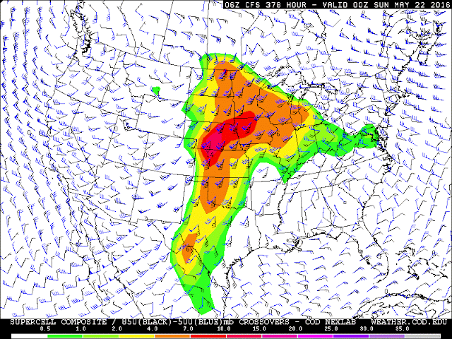
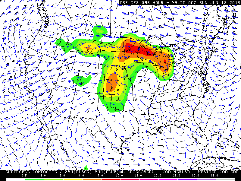
At or around this time, the CFSv2 has persistently predicted these types of conditions at our latitude. This means it has a good chance of occurring somewhere in the country, and that our area could be the "somewhere" it occurs. The chance of it occurring in our area increases the more meridians are included in the area of interest, how often the conditions appear over the course of each run (i.e. once, twice, three times per run), and for how many hours during each run that they persist. The latest run was the most aggressive so far with these features. As you can see in the image above, it predicts ample severe weather parameters over a very widespread portion of the northern plains, upper Mississippi Valley and Great Lakes. It suggests these conditions would persist for several hours and reemerge over the course of several days. Our chances of "getting hit" by a severe weather outbreak go up when this is the case. Most severe weather is "one and done". Situations do arise, though, when the same region or multiple regions can be struck several times over the course of a day or over the course of a few days. This is beginning to produce hints that such an event could manifest.

Our severe weather season tends to be most intense from early June to mid July, but it's not unheard of to see significant severe weather in our state in late May, either, especially not in a year like this one. I mentioned in previous posts that our state's climate this year may be very similar to that of 1998 - current atmospheric and oceanic phenomenon are undergoing similar transitions as to that year, and we all know what happened that year in late May. It's impossible to tell what we're looking at, if anything, just yet, but it's definitely worth remembering that severe weather season is coming up, and now is the time to rehearse plans with your family. Or, in my case, keep plenty of gas in the car and lots of space for photos and videos on the phone, too!

To summarize:

• Long-range models are hinting at a potentially strong/multi-day severe weather event occuring at our latitude between late May and early June

• These "rumblings" are reminding me a bit of the weeks leading up to the June 22nd event last year - wide longitudal dispersion exists and it's enough to make me concerned that Michigan could see something out of it

• Our year is analogous to 1998, which saw one of the most powerful storm complexes in state history strike Michigan in late May

Wednesday, May 4, 2016

Cool day tomorrow, warm, pleasant Friday, and another rainy Saturday


Our relatively uneventful weather (with the exception of today's briefly "interesting" thunderstorm) will continue. Tomorrow should be a quiet cool day with clouds clearing up and highs in the low 60s. Friday is going to bring warmer, slightly more humid air into the state, ahead of a progressive trough which will move through Saturday. This should initiate more rain and thunderstorms.

I still think some of these could be on the stronger side the further south you get, especially toward the Ohio border. Most of us are going to see a similar, if possibly a bit rainier, day as today.

Potential trouble in Huron County

Watching this one closely. A cell moving north WEST appears to be hitting a lake breeze and potentially spinning up. Some rotation detected. This is one of those unique situations thanks to our position and being surrounded by water. No warnings yet and it's just broad rotation as of right now.

Monday, May 2, 2016

Good chance of rain, slight chance of storms tomorrow and Wednesday, bigger chance Saturday


A mid-level vorticity maxima is going to spin down across the state beginning tomorrow, bringing with it a good chance of rain and a very slight chance (<10%) of a thunderstorm or two. This will persist into Wednesday, so most of the state should get at least slightly wet.


The bigger chance for storms comes on Saturday, as ample moisture is expected to stream into the state. Temperatures should climbing to the low to mid 70s, with dewpoints approaching 60°. The latest GFS has backed off a bit from this, and the ECMWF never quite got there, so I'm of the opinion that we're probably looking at 70-72° with a dewpoint of around 55-57°F. That should be ample moisture for thunderstorms, however, as a cold front will descend around that time. The jury remains out on just how much instability will be present, but I'd not be surprised if at least one or two decent storms fire up as usually do when cold fronts interact with warm fronts from the north like this. Wind shear does not look particularly strong from a speed perspective, but the direction does appear to be somewhat right-moving, at least initially. Enough instability could be present for large hail in some areas should any updrafts persist.