Wednesday, June 29, 2016

Upcoming chance of rain looks sadly similar to the last system

Friday's chance of rain may determine whether or not the State of Michigan's fire marshal temporarily bans consumer fireworks (as well as burning) ahead of the Fourth of July holiday. Our conditions are beginning to become dangerously dry in a lot of areas, and while no federal fire risk zones have been issued for Michigan yet, the threat is there and I don't think we're that far away from at least an elevated risk day if we don't get some rain soon.

Our chances may be a bit better than last time, at least according to some meteorologists. The system is forecast to reach deeper into Michigan this time around. However, I'm concerned that what we'll be seeing is nothing more than a repeat of last time for the Thumb with only a slightly more eastern reach. The system may dry out as it crosses Mid Michigan and be completely gone by the time it hits the Thumb. The Thumb would once again remain mostly dry as the system rebuilt to the east over Ontario, and to the south over Ohio. It would be enough to get Mid Michigan wet, but east of Bay City would be out of luck.


With that in mind, the last system was forecast to dissipate sooner than it did last time, with thunderstorms forecast to form over the Thumb. I was supremely confident in the forecast as literally every model was in agreement as to what was going to happen, and atmospheric observations all pointed to the same scenario. Because of this, I along with quite a few experts were left shaking our heads last weekend. If the models repeats their same mistakes, we could wind up getting something out of the remnants from the previous day after all. I hope that this is what happens, as not only are the plants going to suffer but me as well; my allergies are pure misery thanks to the looser pollen/dust in the air and I know a few people in the same boat (the cottonwood trees have been nothing short of brutal). 

For the sake of a loud, eventful holiday free from fire disasters, may all of Michigan get a good soaking this Friday.

Sunday, June 26, 2016

Shocked beyond all measure - The storms skip us once again

I just have no words left for this. I never anticipated that storms would completely skip the Mid Michigan area once again. Everything - every model - put storms in our area right around now. Unfortunately the cold front moved a bit faster, and now the forcing for ascent is to the east of our location.


This frustrates me to the point where I don't even know what to say. I was very wrong about this forecast and I can't figure out Mother Nature at all right now. I am thinking we may be looking at a major drought this year at this point. Our only salvation this week may arrive Friday, but it doesn't look that impressive and with the fizzling of this one - one that looked so promising - any optimism I have left is gone. Next week paints the picture of widespread rain and storms, too, but again, it's all a crapshoot at this point.

100% chance of thunderstorms this afternoon - Severe wind possible

I'm posting my first true disagreeing outlook today. The SPC only expects a marginal chance of severe weather, but with what I'm seeing in the models, surface observations, and feeling in my gut when I go outside, I'm thinking we're dealing with a slightly greater threat for damaging winds this afternoon.


Hi-res NAM4KM guidance is showing explosive thunderstorm development this afternoon in SE Michigan. The HRRR guidance is also starting to indicate some strong cells forming between 2 and 5PM. I anticipate a severe thunderstorm watch to be issued by 3PM EDT and it should cover most of the counties I've shaded in yellow. The biggest threat will be damaging winds from wet microbursts. I think this is a real possibility this afternoon as these storms should explode in a very moisture rich environment. Storm mode is beginning to look more linear in nature, which leads me to believe we could wind up with some bowing structures with some real energy behind them.

We should know a lot more within the next one to two hours. My gut tells me today will be active.

Saturday, June 25, 2016

Western U.P. may be in for rough ride today, while Mid Michigan & Thumb get it tomorrow

The most severe weather in our state thus far this year has actually been in the U.P., where a tornado watch was issued a dozen or so days ago. It looks as though the same area will be under the gun as some rather intense storms are forecast to develop over eastern Minnesota and move eastward.


A very small sliver of the U.P. actually finds itself under an enhanced risk for severe weather. Most of the western portion is under a slight risk, and most of the rest, a marginal risk. This comes from the same system that will hit Mid Michigan tomorrow. The slight risk and marginal risk areas have actually been expanded in the SPC day 2 outlook, as I expected to happen.


Friday, June 24, 2016

Becoming cautiously optimistic for widespread Sunday rain in eastern lower MI

Two more model runs have come in since my original 50/50 sitting-on-the-fence skepticism post, and I'm delighted to say that the results are looking good for rain in the eastern portion of the state. The high-res NAM model in particular has put out some really nice indicators of just the type of soaking we'll need, though there's still some question as to how much coverage areas will see. If storm mode is discrete, as what's currently indicated, some areas may see very little to even no rain. Others may see a ton of rain. Here're some graphics to give you an idea:


This is taken from the 18z (2PM EDT) run of the high-res NAM4KM. As you can see, it predicts widespread rain to the tune of 2"+ over a great portion of lower Michigan. However, it's predicting a discrete storm mode where some counties and areas of counties will see much more than others. In a linear storm mode, coverage has better quality thanks to no gaps between storms. And while it remains to be seen if we'll be dealing with a discrete mode, linear mode or no mode at all (praying not), the 12z (8AM EDT) run has even more discrepancies, and higher totals over some areas due to it predicting some "training" of thunderstorms:


Huron, Tuscola, and Sanilac counties in particular would get a ridiculous amount of rain from this particular forecast, where as the rain would be much more limited to the southeastern portions of the state. Of course, this run can't see past its maximum distance, which means those areas still could get some decent rain coverage, and this is likely a massive exaggeration by the model, but you get the idea.

The other side of the coin of this forecast is storm severity. At this point I'm actually thinking the slight risk may increase in coverage over a wider portion of southeast Michigan, and some of the area might actually be looking at more of a widespread severe weather event should these forecasts verify. The storm mode these two runs have put out indicate discrete severe multicell clusters or discrete supercell thunderstorms, and some areas in particular would be looking at some enhanced potential for such storms. The storms themselves all appear to be right-moving in nature, which is of some concern. I'm not so sure on the large hail risk anymore due to some of the mid-level lapse rates looking a bit sheepish as compared to earlier forecasts, but there is definitely a damaging wind risk being forecast here. Tornado risk is still looking fairly low, but definitely non-zero, and storms that are discrete in nature have a greater chance of spinning up than do storms of a linear nature. Lake breezes are also a wild card in regards to turning non-tornadic storms into tornadic ones. I do not see much of a risk for significant tornadoes at this point, as wind profiles still remain forecast to be on the modest side and shear appears somewhat unidirectional, and even backveering in places. 


Overall, I'm still on the fence. The cap could still hold, and we could wind up with a whole-lotta-nothing. However, I'm definitely leaning more toward storm initiation than against at this point - about 60/40 in confidence level. The severe risk looks legit, but it'll definitely be worth it to get some much needed rain into the soil and onto the trees, which are quickly becoming dry kindling.

We'll get a much clearer picture by tomorrow throughout the day.

SPC issues day 3 slight risk for Thumb area, Mid-Michigan

The latest SPC day 3 outlook has actually exceeded my original outlook for severe weather on Sunday. A categorical slight risk has been designated over Mid Michigan specifically, matching up almost perfectly with the "WNEM" counties.


I'm not sure I'd have gone as far as to issue this outlook just yet. Considerable uncertainty remains regarding some fairly crucial details, not the least of which is capping. While there appears to be ample instability forecast, recent trends show that can be very misleading. There's some indications in the latest models that storms would develop to our south and east over Ohio and Ontario, but completely ditch Mid Michigan once again. Nonetheless, ample moisture should be present at the surface and models do show 850mb dewpoints recovering by 5PM. I'm going to fall in line with the SPC for now, though I'm somewhat skeptical. I could see this outlook falling back to marginal by tomorrow morning.

Thinking positively, this storm system is forecast to suck up quite a bit of moisture from the Gulf this time around, to the tune of 2 inches+ of precipitable water. PWat is a great measurement of rain/thunderstorm potential. If all of the moisture at a given point were to fall as rain, it tells you how much would be available. Once you start getting into values above 2 inches, you're dealing with a very rich, well-fueled storm system. The system in question does appear to be a bit more impressive than what we've dealt with so far this year, at least in terms of moisture and position. The center of a fairly strong closed low is forecast to be present over extreme eastern Manitoba/western Ontario, which is a great place to produce thunderstorms in mid Michigan. We're going to be well into the warm sector, with temperatures again shooting for 90°. The upper level support appears to be quite strong, too, with 250mb winds forecast at 90kts+ just to our northwest. I'd be a lot more concerned if the strength of the low-level jet was higher. As it stands, 30-40kts of bulk shear is the best we're going to have. This should be sufficient for a damaging wind and hail threat in any areas where thunderstorms do form. The tornado threat right now appears small.

My hope is that some convection is able to form this time and we can tap into some of that rich moisture rather than watching it all go to waste again. This state is quickly approaching the point where problems could occur if we don't get some good, widespread rain soon. Unfortunately, in the interest of pure honesty, despite very consistent model guidance, I'm not that confident in this forecast. Too many limiting factors remain in question for me to be liking this, such as capping/subsidence drying and just what kind of mid-level lapse rates we're going to be dealing with. The models have been vastly underestimating capping potential this year, which is one of the reasons they've been so hokey. I'll be more confident if I see a few models showing adequate storm coverage Sunday over Mid Michigan over the course of the next two days.

UPDATE: I'm a little more optimistic after seeing the 12z NAM4KM simulated radar, shown below. This shows either two semi-discrete lines or one semi-discrete broken line which would pivot through the area, bringing a good bit of rain through most of the Thumb. When I've seen this before it tends to indicate a phenomenon called "training" which can lead to a LOT of rainfall - storms form one behind the next like train cars, and douse the same areas over and over. Normally this would concern me for flash flooding potential, but as dry as we are, I can only say, "Bring it on!" Hail/damaging winds/isolated tornadoes would appear likely in this storm mode, too, validating the slight risk, but it'll be worth it if it means not going up like a powder house on the Fourth of July, and if we can have some vegetables in the fall. 


Thursday, June 23, 2016

Decent instability, modest shear Sunday

With yesterday's storms restricted to the southernmost areas of Michigan, our next chance at significant rainfall appears to be Sunday. With all of the troubles the models have been having with the forecast in our state this year, I'm going to try something different going forward: I'm going to discuss each model I have access to individually, briefly touching on the more significant factors that the models are contributing to the forecast, then summarize my opinion.

• NAM: Instability is forecast to increase throughout the day ahead of a cold front which would be approaching from the northwest. A weak cap would be in place and is forecast to erode over most of the state by 2PM EDT. This would support thunderstorm development in the afternoon. Very modest unidirectional bulk shear of 25-30kts would be present around this time, so this forecast does not advertise much of a severe threat. Still, some marginally severe weather (namely, hail) would be supported in the areas of highest instability. The NAM is predicting very high temperatures approaching 90ºF. It has the cold front begin to move through Michigan around 2PM, and thunderstorms throughout the afternoon.

• GFS: The extent of decent instability is forecast to be a bit more limited by the current GFS run, indicating greatest convective potential along and south of the US-10 corridor, and especially east of I-75. Capping is forecast to be a bit stronger in these areas as well. This could go either way - either the cap would erode enough so that thunderstorms, likely initiated elsewhere, would grow in intensity as they approached, or there'd be just enough left to choke off the fuel supply. More time and more runs are necessary to make that determination. Like the NAM, shear is forecast to be modest, in the 25-30kt range, but lapse rates would support a hail threat. Timing of the cold front appears to be similar to the NAM's timing.

• ECMWF: A bit of an outlier in that it has the cold front approach much earlier, and much less instability is forecast to develop over the state, although in a pattern similar to the GFS with the highest instability south of the US-10 corridor and to the east. Same as the rest in terms of shear values, though if this forecast's timing verifies it may not matter. Storms would likely fizzle out due to the cap not having enough time to burn off.


Summary: I'm going with the NAM/GFS on this one as the similar timing overrules the ECMWF solution. Rain and thunder will be likely Sunday afternoon, with a marginal severe threat, especially toward SE Michigan where instability should be a bit higher. The mitigating factor will be cap strength, and whether or not it will erode prior to the arrival of storms which should initiate farther north and west. I do not anticipate any widespread severe hazards at this time. NWS Detroit mentions severe thunderstorm possibilities in latest forecast discussion, though I'm still of the opinion that conditions will be marginal at best due to weak shear values. The SPC lists day 4 (Sunday) potential as too low for a 15% risk area, so they would appear to be in agreement. As such, my official outlook is "isolated severe" for areas along and south of US-10 and east of I-75 (limiting northward extent at this point to favor GFS solution on moisture), and a general thunder risk everywhere else.


Wednesday, June 22, 2016

Risk toward SE Michigan greatly reduced, high risk day unlikely

Some good news regarding the severe weather outlook for today. The models are indicating that the system will take a path more in line with what was originally expected a couple days ago, so the risk for severe weather in SE Michigan is greatly reduced. By no means are we out of the woods, make no mistake; an enhanced risk for severe weather still exists throughout the southern quarter of lower Michigan. A moderate risk also still exists for the extreme southwest portion of the state. With this in mind, I believe this event will be significant, but it doesn't look anywhere near as potentially bad as it did yesterday morning.


Widespread damaging winds are going to be the primary hazard, though a relatively high 10% chance of tornadoes exists for the moderate risk area, and a 5% chance for the enhanced risk area. A slight (15%) risk of large hail exists throughout the enhanced risk area.

Tuesday, June 21, 2016

WIDESPREAD SEVERE LIKELY - Tornado/Severe Weather Outbreak Possible - Wednesday 06/22/16

It's currently 2:52am; I woke to go to the bathroom a few minutes ago, and decided I better make a post now after taking a look at the latest SPC day 2.

Sometimes I think Mother Nature and the Big Guy Upstairs have a pretty morbid sense of humor, or at the very least a sense of irony. Tomorrow is one year to the day of the June 22nd 2015 tornado event that produced the EF2 tornado that hit Millington. Portions of southern Michigan may have something even uglier on the way as what appears as it could be one of the costliest severe weather events to hit Michigan in recent history begins to take shape.


An two-round event almost identical to last years in terms of storm mode and timing appears to be on the way, only this time it's as though nature is trying to make up for 'mistakes' last year in terms of potential. Last year's event had parameters off the charts in the weeks and days ahead of the event, where as this one only danced on the horizon in an obscure, teasing fashion a few weeks back, hid from view for awhile and then sprang to life in the days before. Note that this event is still coming into focus, and for confidence to be this high in widespread, significant severe even at this point leads me to believe more adjusting of the bullseye may take place in the coming hours. Before this is said and done we may be looking at the first high risk day in over two years - since June 3rd 2014 to be specific.

Round one will consist of the remainder of thunderstorms from the previous day along a warm front being generated by a closed surface low which should develop over Wisconsin and Minnesota. These storm are expected to be severe thanks to intense low level wind speeds, with damaging winds and large hail being the primary hazard. A wide area of extremely unstable air is expected to develop throughout the Great Lakes region in the wake of these storms along the moderate risk zone. Widespread mid 60s to upper 70s dewpoints coupled by temperatures in the 80 degree range should produce MUCAPE values of 2000-3000j/kg. As has been the case for the last few times, a capping inversion is also expected to develop after round one, however rather than helping prevent storms this time around, it's going to serve as a ram-rod for the cannon. You've heard me talk about "loaded gun" profiles before, and this is exactly the type of scenario we're looking at. Thanks to intense destabilization, very strong low-level wind speeds and a weaker-than-usual cap, the cap should break and explosive thunderstorm development is likely to occur. This includes supercells with very significant tornado potential, large hail and very widespread damaging winds. Wherever the cells form will have the highest significant tornado threat. After the initial development these storms should merge into a line, and at this point "derecho" is the only thing that comes to mind. This system will have power and that I cannot understate; hurricane force winds being produced along the squall line is not out of the question and could even be likely as this monster plows east. 


I urge anyone along and south of I-69 to go over severe weather contingency plans with their families and friends. Take this one seriously. All of the busts that have happened this year are likely to be made up for in one fell swoop. There's always a chance that it doesn't pan out as forecast, but this ugly situation is more likely to occur than not at this point. As stated before, the bullseye could still shift some, and (God forbid) the ugliness could go further north. I'll continue to watch this and post updates as they come.


To summarize:

A widespread, significant severe weather event is expected to occur tomorrow, June 22nd 2016

• Current target area is along and south of I-69 where an enhanced risk for severe weather exists east of I-75, and a moderate risk west of I-75; the moderate risk also extends east, south of M-59

• Two rounds of severe weather are expected, similar to last year's June 22nd event, with damaging winds/hail in the morning, followed by a significant tornado and hurricane force wind threat in the evening and into the overnight

• The exact bullseye for this one is not yet set in stone, though the SPC is confident enough to issue a moderate risk - as confidence increases, the first high risk day in over two years could be on the way 

Monday, June 20, 2016

Not much severe so far today - Real story Wednesday

A few elevated storms have popped up this morning as instability above the strong cap (which manifested as forecast) has allowed for this development. Most of it is moving through and/or fizzling out rather epically - I just watched a storm go from looking like it could drop quarter sized hail to next to nothing as it crossed the Saginaw Bay. Very little hope for widespread rain out of this one.


The good and/or bad news is Wednesday. We'll start with the good. Widespread rain is anticipated as a closed low is expected to form to our west and tracks over Michigan. Our state desperately needs this rain at this point. The bad news may be what comes with it, especially for the southern third of the state - a true significant severe weather threat.


You may remember mentioning weeks ago at the models hinting at something big for late June. While the models have not exactly been trustworthy, the signals they're all giving off at this point indicate a strong potential of a derecho forming - or at least a highly severe MCS that dances on the edge of being a derecho. Some of the conditions expected are truly off the scale. We're talking 70kt+ low level windspeed, dewpoints in the mid to upper 70s, 0-1KM EHIs of 7+ - the works. If storm mode was expected to be discrete, it'd be a potential tornado outbreak. As it stands, wherever the storms fire are likely to see some major tornado potential, though the storms should merge quickly into a line and plow east at 70+ mph.


For now, this threat is only for the extreme southern portion of the state as far as Michigan is concerned. However, there are some slight indications that the track of this thing could be further north, leading to a much more widespread threat. This system won't be anything to joke around with, wherever it lands. An enhanced risk with a hatched area has already been posted by the SPC for their day 3 outlook. This could go to moderate or high depending on its evolution. More as it develops.

Saturday, June 18, 2016

Dare I say it? Severe storms possible Monday

We're 0 for 3. Last Wednesday's weather evolved almost identically to the weekend before - with a capping inversion killing the chances for thunderstorms across Michigan despite a favorable outlook in the days before. Muskegon and other portions of western lower Michigan actually saw some pretty impressive storms and some wind damage to go with it, but these were storms which had formed over Wisconsin and moved a bit quicker across the lake than originally anticipated, maintaining their strength.

Some pretty impressive wind profiles will combine with a very unstable atmosphere on Monday.
Once again, conditions will be favorable for severe weather, especially further to the north where the upper level winds are stronger.
Now we have a similar situation developing for Monday. The models (a word which I'm considering wrapping in quotes at this point) are suggesting that most previous day convection should fizzle out as a rather strong wind field filters into our area ahead of some truly impressive temperatures/dewpoints. We could very well hit 95°F in SE Michigan on Monday, which is amazing for mid June and demonstrates just how intense of a summer we're looking at. Some very unstable air will be overhead once again, and the wind fields look a little more impressive this time around - 40-50kts of (mostly unidirectional) bulk shear from I-69 south, and 50-60kts to the north. Combined with a cold front entering from the north, this sounds like a great mixture for severe weather. However, a lid could once again be kept on things.

A very strong capping inversion is forecast to develop in the morning, but weaken considerably throughout the day.
Subsidence drying (the drying out of air as it lowers toward the earth from higher in the atmosphere after undergoing convection and cooling to a stable level) has been happening a lot in the storm systems that have affected us. This convective overturn from previous day storms creates a layer of warm dry air at the low levels of the atmosphere, which can keep a lid on thunderstorm development. Another significantly strong cap is forecast to develop by the models early in the day. This cap should erode somewhat by late-afternoon, when the front is forecast to move through. However, it may not erode enough to allow thunderstorms to go up. As such, the SPC has only issued a marginal risk of severe weather for Monday at this point, and its to the south of the state where they predict that the cap will weaken enough to allow any thunderstorm development.

Considerable uncertainty remains, especially after the latest model runs. If the cap is weaker than the models are demonstrating, we could wind up with "loaded gun" profiles, which could equate to explosive thunderstorm development. Hazards in such storms would be very intense damaging winds and very large hail. The unidirectional profile should minimize any tornado risk. The cap could be stronger than the models have advertised (which has happened the last few times), which would mean no storms once again.

It's a flip of the coin at this point. We're either going to have big storms, or nothing once more. More data will be necessary, and even then it will be hard to say what's going to happen right up to crunch time.

Wednesday, June 15, 2016

Putting things into perspective - SPC categorical downgrade

Some of the weather communities I inhabit are jeering this morning at the professionals of the National Weather Service, as well as television meteorologists, hobbyists and others who do their best to figure this stuff out. We've had bust after bust this year. The long range and short term models have predicted very significant events, only to have everything fizzle seemingly moments prior to zero hour due to some unforeseen caveat. Last week, a major capping inversion put the kabash on severe weather and even general thunderstorms in our area. Before that, we had a surprise where severe weather DID manifest to a degree, causing damage throughout the western and northern portions of the state. This was offset by the fact that the SPC issued no categorical severe threat for that day until the storms started to pop up. It would seem like the SPC is batting about zero for us this year.

But here's the thing - convective outlooks are what they are. They're a broad-brush estimation of where conditions for severe weather appear as though they're going to manifest based on the data received at the given time of the outlook. If the data received is lightyears away from what actually happens in the atmosphere, then the outlook is going to be inaccurate. What can look like an incoming event days in advance can turn out to be absolutely nothing. Last year, the models - especially the NAM - were very accurate in their forecasts and I grew to trust them implicitly. The June 22nd and August 2nd events, not to mention a few other minor ones, showed up days, even weeks in advance. Based on model data alone, you could get a good idea of the forecast. This is not the case this year, and it has served to humble me a bit. Nature doesn't conform to the rules mankind sets for her. Just because our computers THINK they understand what she's going to do doesn't mean that she's going to do it. Even when top minds - those with degrees in this stuff - include their observations of satellite imagery, complex mathematical equations, surface and atmospheric data collected by weather balloons, and decades experience forecasting weather, they don't always get it right. 

I've been making my own categorical outlooks for two reasons. The first reason is to practice forecasting where thunderstorms develop and try to compare my results to what the SPC puts out. The second is because I've had my disagreements with the SPC's outlooks and want to make them more clearly, visually known. With that in mind, I simply do not have the expertise to defy the SPC this time around. Rarely do I have enough confidence to claim that they're wrong. The exceptions were on June 22nd and August 2nd of last year. This year I've been deferring more to the SPC because the models have been so hokey. I've had two policies regarding "defiance": 1) I will not issue outlooks containing "widespread likely" or "high risk" unless the SPC does as well, and 2) if the SPC issues a higher risk than what I believe is the case, I will match that risk even if my confidence is lower in the event. I do this because I do not want people to let their guard down based on my observations - I'd rather be wrong and have thunderstorms not happen than be wrong and have someone go out on a boat based on my claims that the SPC is full of crap, then get killed because they failed to take a severe weather risk I was wrong about seriously. So when the SPC issues a slight risk for severe weather, or an enhanced risk for severe weather, I'm going to match it, even if it doesn't pan out.


Where is this going? The SPC has issued a very stark categorical downgrade once again, removing the slight risk for severe weather from all but the southernmost border counties (and only a fraction of those counties are actually included in the risk). However, when you put this into perspective, you'll see that it's relative to the evolution of the system and not necessarily a big miss by the SPC. The downgrade from slight to marginal comes with lower confidence. Short range high-res models currently do not indicate storms developing for all the hours they can see (going to around 9PM). What happens beyond those hours is currently not able to be forecast by these models, so more time is necessary to figure that out. Based on those models and other data, there is still a severe threat in the marginal risk. In fact, the risk for severe storms has actually increased in the northern counties and the Thumb Area from what it was before. This includes a 2% tornado risk for quite a few areas, especially those in the eastern portion of the state and Mid Michigan. 

This one is another of those complex situations where minor details can have a huge impact on what happens in the atmosphere. We've had nothing but those this year. The models have been unable to coherently grasp the dynamics of our weather days or weeks in advance. I'm looking forward to explanations by experts as to why the models are having such a hard time this year. For now, I still think there is a severe threat today. This is based on storm system placement and just gut-instinct. I'm anxiously awaiting more data from the short range models to support it.

Tuesday, June 14, 2016

Wednesday Severe - Enhanced risk cancelled - Slight risk expanded

UPDATE: Editing this post rather than making a new one. The enhanced risk for severe weather has been cancelled. It has been replaced by a slight risk covering the same area and extending further northward into most of Mid Michigan. This is due to lower confidence in severe weather due to lower amounts of shear being forecast and satellite water vapor imagery indicating that air in the storm is drying out as it returns to the surface. However, with the expansion of the slight risk comes potentially wider coverage. With uncertainty on the rise we're likely not going to have a better idea of what to expect until tomorrow, when the short range models and surface observations begin to paint a clearer picture. 

The SPC has put out an enhanced risk of severe weather across southern lower Michigan in response to latest model guidance depicting a more organized system making its way toward the state on Wednesday. Two rounds of severe weather are being predicted - one in the afternoon and one in the evening. This may channel memories of June 22nd last year, though the potential isn't looking anywhere near as nasty just yet.


Of particular importance will be what happens today. Models forecast vigorous storm development to our west, and the resulting remnants may have a huge impact on the placement of the warm front. If these remnants shunt everything south as what most of the models are predicting (the exception being the NAM), then the severe threat will remain isolated further north. However, that warm front could easily encompass the entire area, especially as that storm system ramps up a bit. It has continuously grown stronger in every subsequent run, which has me thinking the models could be underestimating its full potential.


As of right now, the SPC designates only a marginal risk for severe weather exists along and south of US-10 to around the I-69 corridor, followed by a slight risk (15%) from I-69 to the aforementioned boundary. A mere general thunder risk is put out for the thumb and north of US-10. My concern is raised a bit by the opinion of the NWS Detroit forecasters. They explicitly state that the severe threat should cover the entirety of the county warning area by Wednesday night, in contrast to the SPC's assertion that the threat would remain to the south. They tend to be a bit more familiar with the area than the SPC, so this would indicate a greater risk further north than what's being depicted right now. Time will tell.

Monday, June 13, 2016

Monitoring increasing severe thunderstorm potential on Wednesday

I've been watching this one for a few days, but with all the busts as of late due to the hokiness of the models, I didn't want to mention it until the SPC released a categorical outlook of their own. This threat appears, for now, to be most prevalent over the southern portion of the state, from the US-10 corridor south. The eastern portion of the state is currently forecast to skip out on this one because of unfavorable timing, but this could easily change.

The NAM model's forecast has varied quite a bit with this one in terms of placement, but last night's run shows some good potential.
This system is a bit different than the last few that have teased us with thunderstorm potential; it's a bit more organized and better put together. It's what's referred to as a "closed" surface low - a fully mature storm system similar to what we usually see in the late spring (not even close to winter strength). The models are predicting it to fall apart quite spectacularly as it moves into our area, but you know how I feel about the models right now. If the system does hold together, the severe threat could be a bit higher, as it would likely maintain stronger surface, low-level and mid-level winds. Those winds, right now, don't appear anything to write poetry about - only 30-40 knots are being forecast. However, the amount of instability is again predicted to be quite high, characterized by the presence of what's referred to as an "EML plume" - or an area with an "elevated mixed layer".

The "mixed layer" is the area in the atmosphere where all the action takes place. This is the area is the battlefield where the war between warm and cold air is fought. The 'deeper' the mixed layer - that is, the more vertical space on the battle field - the more carnage can take place. The mixed layer is considered "elevated" when it reaches very high up, is particularly deep and very unstable - lapse rates (temperature of air as you get higher) tend to be steep. Such conditions usually result in a weak cap at the lower levels of the atmosphere which prevents thunderstorm activity until peak heating. This is when you can get the explosive growth of supercells and severe multicell clusters depending on how favorable wind shear is for said development. This Wednesday, we'll be dealing with the remnants of an EML plume which is forecast to develop over the plains beginning today. Like all things, this can either strengthen or weaken over time, and the jury is still out on just how unstable things will be, but the SPC is for now predicting at least decent amount of the plume will remain, resulting in 2000-3000j/kg of CAPE.

Wildcards are similar to what we've seen so far this year. Previous-day convection could stabilize the atmosphere and serve to erode this mixed layer to the portion where thunderstorms are no longer viable (as what happened Saturday). Remnants of thunderstorms that produce rain and cloud-cover could cool down the surface and inhibit peak heating. Timing of the system could be off, and result in storms coming through earlier or later in the day, which could move the greatest severe threat around. The system itself could weaken further than the models predict, or be stronger than the models predict when it arrives.

To summarize:

• Yet another chance of severe weather appears "likely" on Wednesday. I'm very wary of putting too much faith in the models right now

• This system looks a bit more organized than what we've seen so far

• Winds will not be strong, but the atmosphere should be particularly unstable due to the presence of an elevated mixed layer

• Main threats would be damaging wind and hail - tornado risk marginal due to lack of strong low-level and surface winds, even though veering winds would likely be present

Friday, June 10, 2016

U.P. under fire as severe weather moves through

For the beginning of this event, the western U.P. is taking the brunt of the storms for now. A very pronounced squall line is moving across the western portion of this area, triggering tornado and severe thunderstorm watches and warnings. Portions of the U.P. have even been upgraded to an enhanced risk of severe weather.

A new severe thunderstorm watch was just issued to encompass the central U.P.
Of most concern to me though is the fact that discrete cells appear to be popping up in the lower peninsula. This would indicate either weaker capping than anticipated by the models, or stronger levels of instability/overachieving temperatures able to overcome said capping. This could bode poorly for tomorrow, when conditions should be even more unstable in the afternoon.

Anticipating storm development based on what's happening vs. what the models predicted

So far, the NAM and other mid- to long-range models haven't handled the forecast very well. Even the short range models are having trouble with this system and predicting where storms are going to form. Take a look at this image:


This is a loop of simulated radar reflectivity starting at around 8PM EDT yesterday evening and progressing until right around 11AM. Notice that quite a few things are different at the end of the loop from what's actually happening right now:


First of all, there's no cluster of thunderstorms over Wisconsin. The blob of rain on the border between Indiana and Ohio is a bit further north than originally predicted, and has held together a bit better. Finally, there's a cluster of showers over western lower Michigan. Now, all of these features are quickly dissipating, however it tells you that the forecast wasn't very accurate in terms of placement of atmospheric activity.

The NAM model seems to favor a more east/west track of activity, while the HRRR is favoring a more north/south track. I think the sweet spot is somewhere in the middle, in which case I'm of the opinion that tonight's storms may affect the north portion of the state more than the south. In terms of new development, the HRRR definitely missed what erupted in Michigan, and if that happens tomorrow, it'll be more than just showers popping up. As such, I maintain the "severe thunderstorms likely" portion of the outlook for most of the eastern portion of the lower peninsula for tomorrow evening, and include the SPC's slight risk area. I think that otherwise the threat for severe weather is marginal at this point.

Wednesday, June 8, 2016

Weekend outlook is a bit clearer, but uncertainties remain

The upcoming weekend will almost certainly bring some severe weather potential to Michigan, but the jury is still out on how much. It's certainly not looking like another June 22nd 2015 anymore; both the NAM and especially the GFS have backed off a bit in terms of the conditional threat.


For now, the SPC has put out a marginal risk encompassing most of lower Michigan for Friday, and a very small slight risk area for Saturday. I have actually expanded this area to include most of southeast and some of the northeastern counties near the Saginaw Bay as some of the models are suggesting increased potential in these areas.


Instability continues to be forecast to be on the strong side. This instability matches the earlier forecasts in the week by the GFS. The NAM is especially aggressive with temperatures, predicting potential 90s on Saturday. I'm not so sure if this is going to pan out, but considering we've already hit 90° in some areas this year, it really wouldn't surprise me that much. The real kicker will be the dewpoints. Both the NAM and GFS are predicting ample moisture presence over the area to the tune of low-to-mid 70s dewpoints, which makes the temperature impact negligible in terms of thunderstorm fuel. Dewpoints that high are going to drive severe weather regardless of whether we're in the low to mid 80s or the 90s, though obviously if temperatures hit 90 we'll have a bit more fuel for the fire.

The system itself is somewhat of a strong one, too, but here's where the forecast has changed. Where as the GFS was predicting 50-60kt winds aloft, the models are now suggesting 30-40kts. This, in combination with less wide-angle windshear, definitely reduces the tornado threat, though I'd still say a slight risk remains. The biggest hazards will be large hail and damaging winds.

Timing of this system is going to be everything. As of now, we're forecast to get a glancing blow on Friday and potentially an MCS from Wisconsin or Minnesota on Friday night into Saturday morning. This means that the storm mode could widely vary between Friday and Saturday. If the system stays the current course, we should have at least some storms fire up in southeast Michigan on Saturday afternoon. Early day convection could suck up some of the energy, and slightly stabilize the mixed-layer, but there's nothing to suggest that it will as of right now. The only real inhibitor predicted thus far would be higher up near the tops of the thunderstorms, where NWS Detroit is predicting "height rises" (pressure increases) from the previous day's storms (in my opinion, this matters a heck of a lot less than the mixed layer). If storms come through overnight rather than early on Saturday, the energy on Saturday afternoon should be greater. If the system speeds up a bit, we could actually see more storms on Friday popping up right in our area, and less of a threat Saturday. This would be especially true for any tornado threat as a speed up would indicate a strengthening, deeper system and likely much more wide-angle shear like what was originally forecast.

Monday, June 6, 2016

Today's surprise severe weather, and coming weekend potential

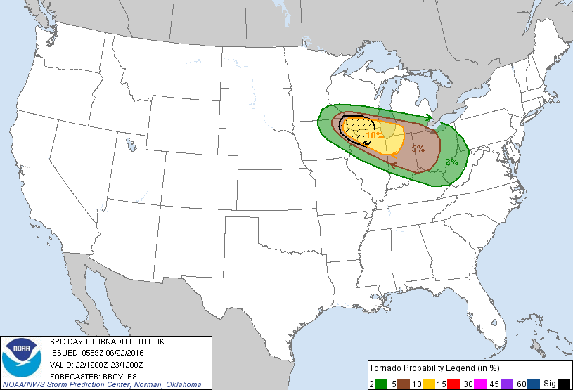
Early this morning, the US convective outlook issued by the SPC looked like this:


By around 9AM, it looked like this:


And by 12:30PM, it looked like this...


...and there was a mesoscale discussion issued for the southern half of lower Michigan indicating a 60% chance of a severe thunderstorm watch.

This is one of those days where nature threw a curve ball, and it has me a bit concerned for what's potentially on the horizon this weekend. 

For starters, I did not see this one coming in the slightest. I'll grant that today has been especially busy and that I didn't get to stop and look at the models this morning as I normally do, but even if I had, chances are I would've agreed with the SPC's outlook. The models - even the short range ones - laid a big goose egg on this one. By 12:00PM it was becoming clear that conditions were a bit more favorable for big storms than originally expected, despite marginal instability. This had to do with a storm system that had strengthened, and the strong winds aloft making up for the lack of instability. In all, we had about four or five severe thunderstorm warnings today if memory serves me correctly, with some decent tree/power line damage reported in about 6 or 7 locations from Twining in the north to Evart in the south.

So why am I concerned?

Well, the models, to put it bluntly, are sucking the big one lately. Forecasts are all over the place. Mr. Torregrossa made an entire article to point out that the weekend temperature forecast looks hokey at best. I agree with him to a point - the temperatures being forecast have been all over the place. However, there has been some consistency on a couple of things, and those things have everything to do with storm potential. The first have been the dewpoints and amount of moisture being predicted. Humidity should be on the increase as the week draws to a close. The models (both the Euro and the GFS) have placed the amount of moisture in the forecast to be quite high, and have been fairly consistent about this. Regardless of just what temperatures are actually achieved, we can assume that it's going to be quite humid - dewpoints of 70°F or higher are going to be possible per both models. The other aspect that has been fairly consistent has been the winds. The latest forecasts placed bulk shear excess of 50kts. That means that wind speed is forecast to increase by 50kts+ from the ground to the mid-levels where the tops of the thunderstorms are located. That amount of shear alone is enough to produce severe thunderstorms. You may have experienced some of these shear-powered thunderstorms today, as this was the primary ingredient for the small event that took place.

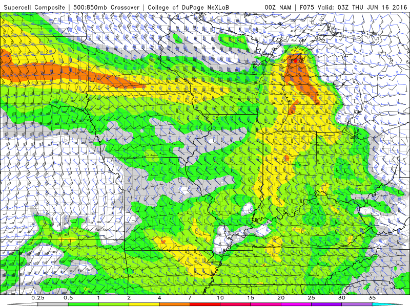
So in looking at today, we're seeing how lack of instability caused guys like me (and apparently a few people over at the SPC) to get caught off guard. Let's see what a situation like this with some added instability could look like:


Let's look a bit closer:


And even closer. Let's look at Pigeon:


Good? How about Caro:


Helicity, CAPE, bulk shear, critical angles and all these wacky technical terms and graphs aside, none of it means jack if we don't get thunderstorms. However, one of two things coming from the north could cause them - a dry line or a backdoor cold front coming from the northeast. I'm especially worried about the latter. Storms would just explode - EXPLODE - in an environment like the one depicted above if any kind of boundary were to interact, but a cold front would serve to turn a few explosions into a full-scale nuclear strike. The mode would initially certainly produce supercells and tornadoes, which would then merge into a line to become a potential serial derecho. The tornadic threat would then be replaced by one of hurricane-force straight line winds. I don't have to mention that the hailstones alluded to in the graphs above would be apocalyptic on their own.

So how does one call this, with the models being as frenetic with the forecast as they've been? I'm not sure yet. I'm leaving my outlook as it is for now - with "severe likely" as my official opinion. As is always in Michigan, this is likely to be an all-or-nothing thing, where we'll either see a horrendous event on the order of June 22nd of last year (or potentially much worse), or absolutely nothing of note. If you want the big storms, pray for levels of moisture/shear currently being forecast and a boundary to go with them. If not, pray for the opposite. My opinion is that differences in temperatures are going to have somewhat of a negligible effect on this should the amount of shear crossing the area be what it's predicted to be. Fuel is fuel, but a motor is a motor, and when you have a fully-loaded twin-turbo with over 400 horsepower, you could only have a quarter of a tank and still be off to the races.

Sunday, June 5, 2016

Marginal chance of severe thunderstorms today in Central/SE Michigan

Latest short-range model guidance is suggesting that strong thunderstorms should develop throughout the region today, and parameters are strong enough that the SPC has introduced an isolated severe risk.


One or two storms could definitely develop damaging wind potential, and surface winds should become strong enough that I wouldn't even rule out an isolated tornado or two.


The latest GFS run has the weekend's severe risk back in the forecast, so I'm not adjusting my weekend outlook for now. I'll continue to keep my eye on it, but as of right now I'd say it's about 50-50.

Saturday, June 4, 2016

Widespread rain to cover most of the state within the next few hours

Still sunny here in the Thumb, but that's going to change in the next couple of hours:


This will give everyone a much needed bit of rain.

Next weekend picture starting to become more muddy

The GFS has backed off a bit on how much instability its forecasting for next weekend, but the ECMWF has stepped up to replace it, predicting between 2500-3000j/kg of CAPE even in the morning hours.


I'm going to leave the outlook how it is for now, but if things don't start clearing up a bit with the next day's model runs, I may just put up a big question mark again. So far everything this year has been a bust for this area, and I'm beginning to wonder just how reliable the long range models are going to be even when in agreement. We may be looking at a severe weather season that either vastly underwhelms, or blooms a bit later in the year. Everything seems to be going around us - either to the south and then up the east coast (as it's happening today and tomorrow) - or fizzling out prior to making it out of the plains. Thankfully some rain appears to be arriving today.

Friday, June 3, 2016

Target time for storms shifts toward next weekend

It's now looking more likely that severe weather could be on the way on Friday into Saturday rather than on Thursday.

Timing aside, the conditions look like they could be strengthening a bit. Each subsequent run of the GFS is predicting a bit more severe potential. The ECMWF is just getting to the point where it can see that far ahead, and so far it's not quite in agreement, but it isn't too far off, either. It's suggesting some pockets of ridiculously moist air in and around the region in the days leading up to the weekend, too:


The biggest reason for my concern is the consistency between GFS runs that has continued to indicate 1) very unstable conditions in/around the Great Lakes, 2) strong low level, mid level and upper level winds, 3) at least some convection developing over the area.

And then there's the appearance of the pattern itself:


This pattern may look familiar to those who remember August 2nd last year:


It's too early to tell in terms of potential intensity, but this forecast sounding is definitely eye-opening: