
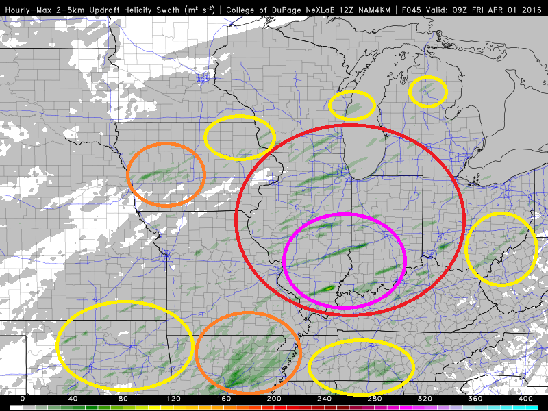
The high res NAM4KM model tends to predict convection (thunderstorms) rather well. This particular product predicts the hourly maximum "helicity" - or spin - these updrafts would have if the forecast verifies in meters per second. Essentially, it's a tornado forecast product (or at least a rotating thunderstorm forecast product). The swaths would be the projected paths of said thunderstorms. The darker the green, the greater the chance of a tornado. The brighter the color, the greater the chance of a significant (EF2+) tornado.
The areas I've circled in yellow have at least some supercell thunderstorm potential according to this model run. The areas in orange have some tornado potential. The area circled in red would appear to have the potential for numerous tornadoes, while the area circled in purple would appear have the potential for SIGNIFICANT, LONG TRACK tornadoes.
This run of the model appears to shift the threat back to the west a bit more than previous runs. It also is a bit more conservative on northward extent of instability. Now, a few things it may not be taking into consideration:
• Cold pockets from previous-day convection inhibiting new thunderstorm development
• Timing of the cold front
Here's what the SPC just put out for tomorrow:

This is pretty much in line with what I'm seeing in regards to our neck of the woods, albeit I think the strong tornado potential (hatched area) might be a bit further north to include the entire "enhanced" (30%) portion. I also think that a marginal risk for severe weather exists well into Mid-Michigan and the Thumb - possibly even further north - based on the dewpoints and wind profiles being forecast (as well as simulated radar and the aforementioned 1-hour UDH), so I've included it in my outlook.
I'm not sold on this presenting Michigan with any more of a severe threat than what was seen a few weeks back. With that in mind, while the wind dynamics aren't quite as favorable this time around, the amount of moisture streaming in is. Anytime dewpoints get close to 60°F with any kind of cold front in tow, the threat of severe weather will likely be non-zero.
No comments:
Post a Comment