I'm still fairly confident that Michigan should see at least some degree of severe weather in the coming week, when two major low pressure systems will begin to affect our weather.
 |
| ECMWF's forecasted position and intensity of storm system #1 for next Wednesday |
 |
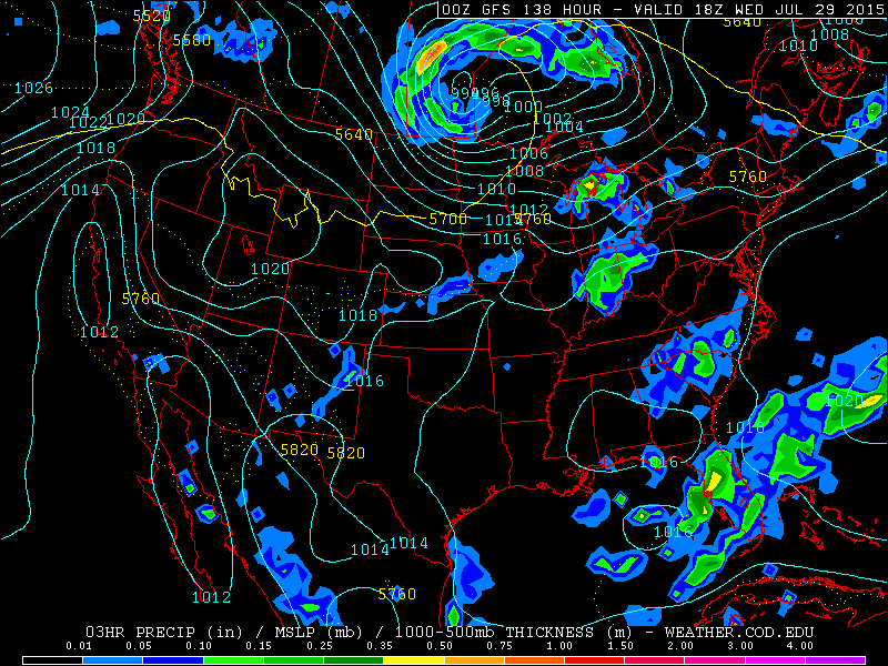
| GFS's forecasted position and intensity of storm system #1 for next Wednesday |
 |
| Temperatures are likely going to skyrocket as this storm approaches and pulls up hot, moist air from the Gulf as it does |
The first storm system looks to be a negatively tilted monster which looks to center itself around southeastern Manitoba by Wednesday, July 29th. Both the ECMWF and the GFS are in close agreement regarding the timing and placement of this system, so at this point I'd call it all but a sure thing. While this storm system definitely looks to be the more powerful of the two, I'm a little less concerned about it, as it may drive too far to the north to bring its full weight and power down onto Michigan. I'd still expect thunderstorms out of this one, but if a storm system like this were to be placed a little further south, I'd be much more concerned. There are a few reasons why this one may give us some trouble, though. The first is that the "heat dome" is looking like it'll be positioned directly to our south again; a strong area of high pressure is looking to be centered right over the Florida panhandle and Alabama. Combining this feature with a strong storm system usually has chances for severe weather in Michigan go up considerably. I'll be watching this one closely.
 |
| GFS's forecast for storm #2. Confidence isn't as high in this one, but I'd still call it very reasonable. |
 |
| Severe chances might be a bit higher with this one due to the storm's position. |
The second storm system doesn't look to be as strong, and isn't nearly as much of a sure thing, but should it arrive where the GFS is placing it, it'll be in a much better position to drive big thunderstorms in our state. The GFS is also forecasting it to have a slight negative tilt, so it could strengthen as it approaches. So far, it's not suggesting that the system will drive temps quite as high as the first one will, but I'd still expect some very warm (if not quite hot), humid conditions to be in place as it plows through.
All and all, given the features of both systems, I'd say we have a pretty good chance of seeing some major thunderstorms in the state next week. Hopefully they'll be timed just right and I'll be able to get some more beautiful pictures without them causing any trouble for anyone.


No comments:
Post a Comment